Hydro #2

So, last weekend saw our Multi-Story Water performances happen around and about Shipley and Saltaire. Thankfully, the weather held out for us – with glorious sunshine on the Saturday, and only drizzle on the Sunday afternoon… A few hours later, the north of England was hit by what the Met Office has called “the worst September storms for 30 years”. So I guess you could say we got lucky! And the feedback on the weekend has mostly been very positive (more on that in a subsequent post).

Predictably enough, our scene discussing plans for the hydro-electric screw on Saltaire weir – at the outset of our Green Route walk – proved the most controversial part of what we presented. Indeed Rob Martin, chair of the Saltaire Village Society, was prompted to write to the Telegraph and Argus with the following letter (original link is here):

SIR – It was a pleasure to take part in Multi-Story Water over the last weekend in Saltaire. The boat ride with singing by Eddie Lawler and two walks along the River Aire up and downstream from Saltaire provided lots of information in an entertaining way. Some information, however, was not correct. At one point, the audience stood on a slope in Roberts Park at the site of a proposed turbine house for a hydro power scheme. We were told that once installed it wouldn’t be noticeable. In fact, the slope with four mature trees on which we were standing would become the flat roof of the turbine house, with a railing to stop us falling off. The audience was also told that local people are against generating hydro power from that weir. This is untrue. Saltaire Village Society opposes siting a scheme on the Roberts Park side, but advocates it for the opposite bank, where water power once drove large water wheels for Dixons Mill (where James Roberts built the New Mill).

Rob Martin, chairman, Saltaire Village Society, c/o Albert Road, Saltaire

Unfortunately, however, Rob is himself guilty of misinformation here, not least the claim that New Mill was built by James Roberts. (Titus Salt constructed it in 1868.) The claims he makes about our performance, moreover, are simply untrue. As I have noted in a response to the T&A (remains to be seen whether they publish it), “the performance did not, in fact, make either of the claims that Mr. Martin suggests. He writes: ‘At one point, the audience stood on a slope in Roberts Park at the site of a proposed turbine house for a hydro power scheme. We were told that once installed it wouldn’t be noticeable.’ Nothing of the sort was said. We stated that ‘some have argued that the hydro installation will spoil the view’, but also that ‘the scheme is designed to enhance the visitor experience’ (which it could hardly do if it wasn’t noticeable!). Secondly, Mr. Martin claims that ‘the audience was also told that local people are against generating hydro power from that weir’. Plainly this is not the case, not least because many local people are in total support of the scheme. Our script stated simply: ‘some have argued that this modern installation is inappropriate in a Victorian heritage site’ – a statement which neither side of the argument could dispute!”

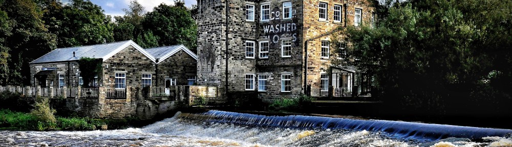
In the interests of full disclosure, I am pasting in, below, the whole script for this section of the performance. However, in this fuller blog-post format, I also just want to query Rob’s suggestion that “the slope with four mature trees on which we were standing would become the flat roof of the turbine house.” The particular spot we were standing on, just downhill of the footpath leading to the bridge, clearly remains – in the architect’s drawings of the scheme – a piece of grassy slope with trees:

Our scene was placed to the left of this image, on the slope just behind where the lone figure stands at the railings. Actress Lynsey Jones gestured towards the area next to the weir where the turbine house would stand, according to the plans, and pointed out that “currently there’s just a lot of overgrowth” along that stretch of the river’s edge (again, a point which is difficult to dispute). In short, unless the plans for the scheme have been radically revised since the July 5th public consultation at which this and other images were displayed, I would defend the accuracy of our script. It is perfectly reasonable to disagree with our position on the hydro scheme (it’s fair to say that the performance struck a position broadly in favour the proposals), or to dislike the playfully theatrical tone in which we presented the scene (which, I can now see, could be considered insensitive to the very real pain that the arguments have caused for some in the Saltaire area). But that does not mean that anything we said was, per se, untrue.

OK, honour defended, here’s the script section I promised. Judge for yourself:

LIONEL: Time flows on…

ALISTAIR: …metaphorically, like a river. But also cyclically, like a wheel!

DOROTHY:  Now water power is making a comeback here…

LIONEL: In the form of a hydro-electric power generator…

DOROTHY:  An Archimedes screw!

DOROTHY:  Here on Saltaire weir…

LIONEL:  Here on the Roberts Park side, because Bradford Council owns the park –

ALISTAIR:  And it’s Bradford Council that’s proposing a screw in the river.

DOROTHY:  Now, this is proving to be quite a controversial. Some have argued that the hydro installation will spoil the view…  although if you look at the designs, the placement would be here, where currently there’s just a lot of overgrowth…  (pointing it out)

ALISTAIR: You see, the scheme is designed to enhance the visitor experience.

LIONEL: Some have argued that this modern installation is inappropriate in a Victorian Heritage Site…

ALISTAIR:  In that case, so is the weir. Take it down!

DOROTHY:  (ignoring him) … but the CWHPHACIEESS proposes a more embracing, encompassing understanding of heritage.

LIONEL: Not frozen over, but flowing on into the future.

[There then followed a reproduction of sections from an interview with Neill Morrison, of Bradford Council. Admittedly, it was less than “even-handed” to include Neill’s position without presenting a counter-argument, but this part of the script is more interested in the wider “climate change” argument than the hydro scheme per se…]

REPORTER: According to Bradford Council, the future could be stormy.

SIGNAGE 1: BE PREPARED TO TAKE ACTION!

REPORTER:  Said the signage at the recent public consultation about the proposed hydro installation.

SIGNAGE 2:  CLIMATE CHANGE IS HAPPENING!

SIGNAGE 1:  ARE YOU READY FOR CLIMATE CHANGE?

SIGNAGE 2:  The weather in Bradford is changing. We must adapt our property, communities, and lifestyles for more extremes of weather, such as..

SIGNAGE 1: frequent floods

SIGNAGE 2: severe winds

SIGNAGE 1: heavy snowfalls

SIGNAGE 2: heatwaves

SIGNAGE 1: droughts.

(beat)

REPORTER: (to herself)  Crikey!  (beat – then, to the public…) We spoke to Neil Morrissey.

NEILL: Morrison,

REPORTER:  Neill Morrison…

NEILL: I get that all the time.

REPORTER: Energy Management Officer for Bradford Council…

NEILL:  You look at how the weather’s changed over the last thirty years… we’re getting more extreme weather, more often. Every year it’s the wettest June or the driest January … This year we’ve had this weird situation where the rivers were really dry in March and April, when they should  be stonking – and then in June when they should be at base flow and nothing spare, it was pumping out here for weeks… I kayak for a hobby so I notice it. And down in Calderdale, they had the worst flooding in recorded history…

REPORTER: But is it Bradford’s responsibility to solve climate change?

NEILL: (a small sigh) It’s everyone’s responsibility to solve climate change.  There is no, ‘whose responsibility is it?’ That’s part of the problem, that’s why stuff doesn’t get done – everyone’s blaming someone else.  You can’t use that as an excuse any more. You have to – do something!

REPORTER: But surely something like this hydro is just a drop in the ocean of what’s needed.

NEILL: Of course. But you cannot have one thing that will fix the situation. You’ve got to have lots of schemes, lots of technologies, and they’ve got to complement each other.  So you start by looking at what we can do in this district – and at the assets we have. We have waste, which we’re working on… we have wind, but frankly the argument over wind will make this look like a storm in a teacup. Imagine what the Bronte Society would say if we said “oh we want to put wind turbines on Top Withens.” You cannot blend them in! But we think we can blend this in…  With hydro, there’s a chance here. It’s about making the best of what you’ve got.

[extract ends]

Anyway, I hope that puts the record straight. But perhaps, considered in the great scheme of things, this is all just (as Neill put it) a “storm in a teacup”… We have bigger storms to worry about.


Hydro!

The hottest water issue in Saltaire at present (sorry, no pun intended) is Bradford Council’s proposal to install a hydro-electric power generator — an Archimedes screw – on the River Aire at Saltaire weir. The controversy raging is around the fact that the site proposed is within the grounds of Roberts Park, which Bradford Council owns, but which it is by no means free to do with as it wishes. The argument against the installation can be simply summarised as follows: “the project changes the use of a recreational park space, and has no place in a protected park, in a protected conservation area, in a protected World Heritage Site.”

Those words appear about half-way through a document titled “Reasons to be Doubtful”, which has been carefully prepared by “a group of concerned villagers” (no author is identified). The latest, September version of this document (it continues to evolve as more information becomes available) was the key persuading factor in the decision last week by the Saltaire Village Society to come out in opposition to the proposals. (See news report here.) A copy was provided to me by Rob Martin, chair of the SVS, and also coincidentally one of the performers in our Blue Route canal tour. His fellow performer on the boat will be Eddie Lawler, who remains in favour of the hydro proposals — just one small indication of the way that this plan has divided the local community. It’s a very sensitive issue, with strong arguments on both sides.

So what’s the argument in favour? At a public consultation about the proposals at Saltaire’s URC Church on July 5th this year, the signage on the way into the church’s basement exhibition space made the Council’s case pretty unambiguous:

Technically, of course, building a renewable energy plant constitutes “mitigation” of climate change rather than “adaptation” to it. That is, it helps reduce carbon emissions (all other things being equal), but does nothing to prepare us for adverse or extreme weather… Most scientists are now in little doubt that we need to be doing both, so the hydro plan is part of Bradford’s response those uncomfortable realities – and at least it is doing something! The Council’s main persuasion tactic seems to be to appeal to the green sensibilities of the local population: Shipley ward elects the only Green councillors on Bradford Council, after all (even if the MP, Philip Davies, is a climate change sceptic!).

Presumably we could add “Support renewable energy schemes in your area” to the bottom of that list… But what the Council have not done very clearly here is link this notion of global change, global responsibility, to the particularities of a local place. And it’s often difficult for people to see what difference small, local changes will make to the big, global picture (even though a lot of small changes might add up to a big one!).

It seems to me that the Council could have been much more explicit about admitting that the choice of Saltaire weir for this hydro scheme is as much a symbolic one as a practical one — that it’s a showcase scheme designed to draw public attention to the wider need for a switch to renewable energy. The objections to the scheme in the “Reasons to be Doubtful” document mostly relate to the inappropriateness of placing a power plant in a recreational park: indeed the authors make the point that such usage may contravene the terms of the deed of gift by which the Roberts family gave the park to the City in the 1920s. But if the hydro is constructed and displayed in such a way as to add to the interest value of the park for visitors, then the installation would presumably be enhancing the park’s “recreational and amenity value” rather than detracting from it. And clearly that is the intention here… You only have to look at the aesthetically rendered visions of the hydro installation on display at the July 5th consultation…

This diagram image, and its keenness to interpret and explain, seems to reflect a key aspect of the hydro plan — i.e. that it should serve as a pleasantly-designed educative exhibit, as well as a working power generator. None of this seems to me inherently objectionable in a conservation area or World Heritage Site, especially given that the return to “water power” signalled by the hydro installation also symbolises a cyclical return to the site’s own history. The weir is here in the first place because it once served a water mill – Dixons Mill – that stood on the southern bank before Salts.

In point of fact, even the protest lobby against the scheme seems to be aware that the hydro installation might add to the amenity and visitor value of the park. How else to explain the last point on the placard below? (sited at the ‘picket’ point outside the July consultation)

That final point suggests that increased traffic congestion might result from the added ‘attraction’ value of the showpiece hydro installation. And yet at the same time, there’s the assumption that it will be a burden (“Saltaire bears the brunt”) and an eyesore (obscuring views). The argument is somewhat self-contradictory, and perhaps somebody pointed this out to the ‘No’ campaign: it’s telling that the “traffic” objection is nowhere apparent in the September “Reasons to be Doubtful” document.

I have to say that I’m not convinced, either, about the suggestion that ‘iconic’ views will be spoiled by the installation: if you go down and look a the proposed site at present, the views from it are already partially obscured by self-seeding riverside foliage growing out the banking. Purely in aesthetic terms, the designs for the installation would appear to be an improvement, visually. The “Reasons to be Doubtful” document does mention that pulling out trees (presumably these ones) is an environmental no-no. Yet a much more substantial swathe of riverside greenery was pulled up during the Lottery-funded improvements to the park only a few years ago – precisely in order to clear the views from the cricket pitch to the bridge, Boathouse and Salts Mill…

But I’m digressing. Let’s return to the key argument. If one accepts the proposition (and plenty of people don’t!) that a hydro of this sort is a kind of showcase exhibit, with a symbolic and educative value beyond its purely practical, energy-producing function, then most of the objections in the “Reasons to be Doubtful” document fade away pretty quickly. “There is only a modest green gain.” Well yes, nobody ever said water could be harnessed to enormously powerful effect (there’s a reason we once switched to steam mills from water mills!). The point is not that this one hydro would generate huge amounts of energy, but that many similar, small-scale schemes up and down our river catchments (coupled with other schemes to create power from wind, waves, waste, etc.) might start to make a difference to our fossil-fuel dependency. “This scheme represents poor value for money.” Perhaps, but by the “Reasons…” document’s own reckoning, the additional cost in comparison with – say – the hydro at Hirst Mill being proposed by Sustainable Saltaire, is mostly caused by the need to make the installation appropriately presentable in a protected heritage context. Again, that price might well be worth paying for the public showcase value. And besides, Bradford Council’s figures, even at the conservative end, indicate that this hydro would pay for itself within a decade or so.

The “Reasons to be Doubtful” document does, however, ask a few searching questions about the green credentials of the scheme. Has anyone calculated what the actual carbon expenditure would be to install the hydro in the first place? Because without such an estimate, we can’t be sure what the net energy savings would really be of such a scheme, as opposed to the gross power generated. Not only that, the document refers to this proposed hydro as a “token gesture”… If it is to have symbolic value as a public exhibit of the virtues of green energy, it needs to be evident that it not tokenistic, but one scheme among many (the showcase scheme among many) that Bradford Council is developing. Otherwise it really would be just window-dressing, or “greenwash”. So there are still questions that need to be answered persuasively by the Council.

And perhaps the most persuasive argument on the “anti-” side is simply that the gestural value of installing such a showcase turbine does not stack up against the potential inconvenience value to the local community… Roberts Park was largely closed off for redevelopment work only a few short years ago, and although nobody disputes that the result is a vast improvement on what was there before, the prospect of part of it being dug up again so soon is understandably off-putting. This is the point that Rob Martin emphasised recently in a piece for the Saltaire Sentinel: “[visitors] would be walking next to a building site for the 14 to 18 months, and it will be even longer before the site resembles anything like the artist’s impression of the finished article. It seems to be very high price for a little bit of sustainable energy.” The counter-argument here, I suppose, is something along the lines of “you don’t make an omelette without cracking a few eggs.” So again, it all comes down to a question of how much you want that omelette.

There are, as I said at the outset, strong arguments on both sides here – although it’s probably clear which side of the debate I favour (and hey, I can afford to: I don’t live in Saltaire and won’t live with the inconvenience of the construction). What I find disturbing in this, however, is the insularity of the way the debate has been framed by some on both sides. The anonymous “concerned villagers” behind the “Reasons to be Doubtful” document seem to have forgotten that they don’t actually live in a “village” entire unto itself, but in a district of Shipley, which is a district of Bradford… But look again at that placard I photographed above – “in our park,” “we” shouldn’t be having to export energy “across Bradford”. Whoever wrote that needs to ask themselves where they get their “own” food, clothing and energy from. Saltaire village is not yet a self-sufficient co-operative. But equally, the Council pitch on July 5th seemed to be pandering to the same presumed, insularised village mentality. Check this out:

I’m not sure I’ve ever seen this “harsh urban edge of Coach Road”. In fact, the Coach Road housing estates, lying on either side of the park, were carefully planned by Shipley Urban District Council, back in the 1950s, precisely in order to preserve the “rural aspect” of the surrounding area (Shipley Glen, Baildon Moor, Hirst Wood…). You can see that especially with the very sensitive design of the Higher Coach Road estate (which will shortly be the subject of another blog posting). Unfortunately, the words “harsh urban edge” seem here to function as code for “those people over there in the housing estates” – wouldn’t it be nice to “screen” them off from “our” park? Well, folks, those people (many of whom are very lovely people, by the way) live in this area too, and the park is on their side of the river.

As park-keeper Martin Bijl is keen to emphasise, the policy of Roberts Park is – quite rightly – to be inclusive and inviting for people from both the north and sound of the river, and indeed from much further afield. In a World Heritage Site, we need to be thinking in terms of a global village.

Rights of Way

One of the most intriguing questions to explore in the Shipley area, in relation to the river and canal, is the question of public rights of way. Over hundreds of years, certain riverside tracks have developed a status as public footpaths which is now legally enforcible. “Once a highway, always a highway,” is the old adage – according to Bradford Council’s rights of way manager Danny Jackson. Except of course, as Danny’s the first to acknowledge, there are exceptions to that rule. In the 19th Century, after buying a huge swathe of land to the north of the river, all the way from Milner Field to the west, down to Lower Holme in the east, Sir Titus Salt succeeded in having pedestrian access rights moved away from the riverside and onto his new Coach Road. Originally, Coach Road was a private road for vehicles, but a public one for pedestrians. The same went for the Victoria Road bridge at Saltaire: pedestrian access rights were moved to this bridge, and Salt took away the ancient river crossing consisting of stepping stones! In the 1960s, when the road bridge had to be demolished as unfit for vehicular traffic, a new footbridge had to be built by law, in order to restore the public right of way!

Anyway, Sir Titus’s legal footwork explains why, today, there is no official riverside path on the north of the river betwen Baildon Bridge and Hirst Wood. Once you get to Hirst Wood, it reappears: there’s a lovely walk up to Dowley Gap and beyond. But the path running east from Baildon Bridge towards Charlestown (featured in my recent “Lower Holme – picture story” posting), is in a much more precarious state. Though utterly neglected, it’s still there – having survived all the mill demolitions going on around it. But in places the path is very narrow and even treacherous underfoot. Riverside rights have clearly not been at the top of the planning agenda in that area…

Recently, I took a walk with Danny Jackson along a stretch of river path that Bradford Council are paying particular attention to at present. This stretch, also ancient right of way, runs along the South side of the river, between Salt’s Mill and Baildon Bridge. With us on this stroll was my 7-year old daughter Eleanor (seen here outside Saltaire’s gorgeous URC church), who was entrusted withthe task of photographing whatever she thought was worthy of note along the route. The images below are a child’s eye view of the path and its various delights…

Danny and his colleagues have been charged with opening up and improving access along this stretch of path, because it links Saltaire to the recent residential conversion at Victoria Mills. In order to secure planning permission, the Victoria Mills development had to agree, under Section 106 of the Town and Country Planning Act of 1990, to commit funds for these ‘highway’ improvements (it’s all detailed online here). The irony, though, is that there is currently no demand from the residents of Victoria Mills to use this riverside path – and the gate that would provide access to it is normally padlocked for security reasons. Instead, the residents tend to use the nearby canal towpath for walking. So what would really encourage use of this rather run-down path?

We began on the canal towpath outside Salts’ New Mill, since the mill itself prevents any direct access along the riverside at this point. It’s tempting to blame Titus for this too, but in all likelihood the path would always have bent around the water mill (Dixon’s) that was on this site before Salts. Eleanor’s picture highlights the rather unkempt, overgrown state of the path even in this World Heritage Site section.

When you cut down towards the river though, things rapidly become much less inviting…


The river path is slippery with moss in numerous spots…

… and decorated with charming touches (though Eleanor felt this could be a place to hang art work!)


Time to let Eleanor’s eye do the talking…


Eleanor liked these thistles a lot… They’re wild flowers, of course – ‘weeds’. As I discussed with her, letting things grow, or ‘letting things go’ isn’t always a bad idea. The thing she liked most on this walk were the little blue flowers on this plant (and others like it) growing unbidden out of the perimeter wall at Victoria Mills… It’s a cliche to say it, perhaps, but nature will find its own right of way….


Lower Holme – picture story

Under what circumstances might a new-build KFC going up near your home seem like a good idea? Read on and decide for yourself…

Shipley’s history (like Bradford’s more broadly) is inextricably tied up with the history of the wool industry and its mills… A particular mill site that has interested us during the Multi-Story Water project (it’s the location for the closing scene of our ‘Red Route’ walk) is Lower Holme mill, on the north side of Aire slightly to the east of Baildon Bridge.

To orientate your a bit, here’s an image not of Lower Holme but of the adjacent site, when it was occupied by the Airedale Combing plant. In this shot you can clearly see the River Aire towards the bottom left – running down from the weir that used to serve the long-disappeared Baildon water mill. The image gives you an idea of the sheer scale of Airedale Combing, once one of Bradford’s most advanced mills….

Note also in this shot the pathway that cuts diagonally across the bottom left corner of the combing plant. This is the ancient right of way along the north bank of the river – which cuts inland slightly at this point before meeting Otley Road near Baildon Bridge. That same route is still there, because it’s a protected footpath – but everything around it has since changed!

In this shot, we’re looking from the opposite angle to the first one — so that’s Airedale Combing again on the right, with the river visible above it in the picture. And next to it is the sprawling site of the (even bigger!) Lower Holme mill… The lot it occupies was owned for a period in the 19th Century by Titus Salt himself, and local historian Ian Watson believes it may have beeen the site originally intended for Salts Mill itself (his persuasive argument is outlined in his pamphlet “The Land Acquisitions of Titus Salt in Shipley and Baildon”). But Salt never developed the site, and sold it on to C.F. Taylor in 1862. To many people, the mill site is still known simply as “C.F. Taylor’s”.

This shot – clearly more recent! – shows Lower Holme, with a rather different set of buildings, following the demolition of both Airedale Combing (the empty site at the top of the picture — now occupied by B&M and other retail outlets) and the next mill along. Note that the line of the ancient riverside path is still clearly visible, curling between the buildings at the top of the shot (it’s now thoroughly fenced in!). Note also the two facing rows of Lower Holme’s mill houses in the bottom right of the picture. They’re the only buildings still standing today, and are still occupied by residents (about fifty-fifty private ownership and Accent Housing Association). The angle below, from the same helicopter fly-past, shows the houses prominently in the bottom of the shot…

Looking at this image, it’s worth bearing in mind that – according to the Environment Agency’s flood mapping, the entire space between the river (top of shot) and the road (bottom) is flood plain… All of those houses could flood in an extreme event, although in 2000 – during the last major flooding in the Shipley area – only the first four houses on either side, nearest the river, suffered from flooding, and at basement level (water coming up through the ground) rather than flowing in at ground level.

In a sense, the more serious “flooding” suffered at Lower Holme has been from economic rather than hydrological causes… Here we see the current, derelict state of the Lower Holme lot – with only one of the mill buildings surviving, just to the south of the mill houses. This was converted as flats just before the bottom fell out of the property market in 2008 – and the building remains unoccupied, with broken windows etc. Meanwhile, the new residential development planned for the cleared mill site (demolition was in 2006) never even got off the ground…

The property developers in question, the Mandale Group, have left these fetching metal hoardings surrounding the site for the last five or six years — creating something of an eyesore for residents, and arguably attracting “undesirables” to the area (as in the ‘broken windows’ theory of anti-social behaviour – if a place looks neglected and uncared for, it will attract carelessness…).

As you can see from this shot, taken a couple of months ago, Mandale have been trying to sell the site on for some time…

And in the absence of the developers, the riverbank itself has started to reclaim the site. One of the Lower Holme residents, Lynda, has walked around the derelict site and identified the ‘weeds’ as common riverside plant species…

The story has a new twist, though, because Mandale have recently succeeded in selling the site, to Marshall Commercial Developments. James Marshall, who is (rather intriguingly) the son of the man who oversaw the conversion of the Airedale Combing site into the current retail park area, has kindly provided the planning diagrams below, which show what he’s intending for the site… (as he says, they’re in the public domain, so there’s no secret about them – but the planning application has yet to be approved)

To see the picture at full size, just click on it. The eagle-eyed viewer will note that the developer named on the plans is “Mandale Commercial”: Marshalls are basically planning to move ahead with the last set of plans that Mandale had drawn up. The difference is that, where it seem Mandale was badly hit by the downturn in the property market, and could no longer borrow the money to pursue the build, Marshalls can afford to pursue the project because they don’t need to borrow. As a family firm for four generations, they have kept their assets in the company, to secure longevity (rather than stripping them out at the first opportunity). The main part of the site, then, will be occupied by a KFC – to the left of the plans, facing the main road – and a Wickes DIY store, to the right, next to the river. There’s also quite a bit of car parking space, and the old mill building is designated for “offices” (though James tells me it may end up as social housing).

Anyway, here’s what the KFC might look like, if they get planning permission…

What do you think? Is the potential nuisance value of having this near your home greater or less than the current nuisance value and eyesore of having the mill site indefinitely surrounded by ugly metal hoardings….?

Lower Holme’s residents have until this week to lodge any concerns they have with the planning authorities. What would you say?

(P.S. A week on… with the planning objection deadline having passed… and I learn that not all of the residents had even been informed of the planning application! Surely insult added to injury.)


Incidents and Accidents (and Medicis)

I’m acutely conscious that I haven’t been doing a very good job of keeping this blog up to date… what with having been so busy with the planning and scripting of our performance events coming up in September, and dealing with the small matter of moving jobs (from Leeds Uni to Manchester Uni, though that shift doesn’t affect this project). So to start to bring things up to date, here’s a room I was in yesterday:

Doesn’t look very exciting like this, to be sure, but this is the Incident Room at the Environment Agency’s Yorkshire offices at Phoenix House (on the South side of Leeds). So this was the nerve centre of the EA’s emergency response during the recent flooding crises in Calderdale (Hebden Bridge, Mytholmroyd, etc.). You must fill in, through your imagination, images of people frantically charging about, sticking post-its on the boards at the back…

I’ll say more in another post (promises, promises) about the productive meeting with EA representatives that I had in this room yesterday, but right now I’ll rewind back a few days more to last weekend… when I returned from my summer holiday to discover that, while I was off sunning myself in Italy, there had been flash flooding very close to Shipley… just to the South in Frizinghall. See this BBC report. In fact, the Frizinghall area falls at least in part within the Shipley ward, and it was very much on our radar when we started this project (see the “Photo Tour” page of this site and scroll to the bottom) — partly because EA flood maps for the area indicate a clear risk of flash flooding on Red Beck, a tributary of Bradford Beck. Red Beck comes down a fairly steep incline, and is largely culverted underground, so if you stand on the streets it runs under or between (Redburn Road [!], Wharnecliffe Rd. and Norwood Avenue) you would never know you were in a flood risk area… It’s certainly not on a ‘plain’, and there’s no sign of water. Which is kind of intriguing, but the area’s geography also made it very tricky for us to build effectively into this project — largely for aesthetic reasons (there’s little sense of visual spectacle or intriguing history to work with in this area, in creating a performance event), but also partly for reasons of sensitivity: nobody here is going to thank us, we thought, if through performance we draw public attention to this place as a potential flood zone… because people might well worry that such exposure might affect property values, insurance premiums, etc. So we decided to focus our project’s attentions on the Aire’s journey through Shipley (where flood risk should be self-evident)…  But now, of course, Frizinghall has had public attention drawn to it anyway.

There’s an irony of some sort in here… But since I’m not sure what it is, let’s instead scroll back slightly further to that Italian holiday I mentioned. We were in Tuscany, which is a bit of a tangential leap from Shipley, in terms of site specifics, but this project was still on my mind of course. Which is why I was intrigued to discover this map in the Palazzo Vecchio in Florence…

Palazzo Vecchio is the former seat of the Medici dynasty, the building that Michaelangelo’s David stands at the doorway to (well, it’s a replica David now – they moved the original safely indoors a while ago). Inside is the ‘map room’, right next to the room that was once Niccolo Machiavelli’s office… It contains maps of every part of the known world – as it was known back in the 15th Century – so like that EA office it’s a kind of panoptic incident room – an expression of the Medicis’ power of surveillence over the known world. And if you look closely at this rather wonky map of the British Isles…

The word “Leaf” in the middle is presumably Leeds, “Vachefeld” is Wakefield, and it doesn’t take a genius to work out what “Halaifax” is (even if it has become rather oddly proximate to Preston!). Weirdly inaccurate as the mapping certainly is, you can see how the Humber catchment is the key way in which the North of England has been mapped (presumably by people travelling on boats upriver, given that15th C. roads would have been a bit ropey…). The Humber catchment of course includes the Aire, and there it clearly is, disappearing into the Pennines past “Leaf”…

Of course in Florence, the river is the Arno (which has four letters and starts with A, so I’m claiming a Radio 2 link to the Aire), which features very prominently on Renaissance representations of the city…

As you can see from this drawing, the city’s very flat… It’s very much built on a flood plain (even despite all those medieval hilltop towns in the area…), as too is Pisa — which is further downstream on the Arno, as it widens to meet the Mediterranean. It turns out that the leaning tower of Pisa, which (I can confirm) really does lean…

… is so tilting because it’s built on the flood plain (even though it is quite a distance from the river), and thus on land which is basically alluvial silt. Apparently it took them centuries to realise that the architecture of the tower wasn’t the problem, just its footprint on this very squishy bit of earth. Just within the last twenty years they completed work to stabilise the tower by sucking up earth from underneath the north (non-load-bearing) side, so that the building sat back on itself by a few degrees. They could have kept going, apparently, and turned it into the Non-Leaning Tower of Pisa, but they figured that would be bad for the tourism.

Regardless, this puts in a funny kind of perspective the 1950s housing estate that Shipley Council built on Coach Road next to the Aire, also on alluvial silt… The architects realised that if you put too much weight in any one spot then the buildings would sink, so these houses were built without foundations or basements. Basically they’re constructed on concrete ‘rafts’ that are, in effect, floating on the surface of the land, with the rafts distributing the weight of the building across the whole surface area rather than at particular pressure points. Under people’s carpets is a layer of asphalt, which is smeared onto four and a half inch thick concrete slabs, and below those is a bed of hard core, and that’s it… The houses are floating, but at least they ain’t leaning…

By the way, if you’re wondering why I know so much about the precise widths of concrete in the floors, well…. that’s for another posting…

A Midsummer Night’s Dream…

The other night, Monday June 25th, I had the opportunity to join David Robinson and his dog Oscar on their evening walk up to Shipley Glen from the Higher Coach Road estate. Despite having spent a lot of time now, working on this project in the vicinity of the river, I hadn’t previously been up the hill for want of someone to show me the way around. David generously offered to do the tour – and we just happened to pick what turned out to be an utterly glorious evening of midsummer weather…

Our luck with the weather was all the more remarkable given that, only a few days earlier, the miserable rainy conditions we’ve experienced during much of June resulted in flood warnings across the county. Although the worst of it was in the Calder Valley rather than the Aire, the high water here was still more than apparent at the swollen Hirst Wood weir just yards upstream from David’s house (which faces directly onto the river). In the image above, a tree has been carried downstream and caught on the weir – it’ll have to be cleared by the Environment Agency, I presume.

David told me that he received an automated call from the EA on Friday night advising him to take precautions and move personal items upstairs because the Aire was about to burst its banks. Despite having never previously received such a call (he didn’t even realise he was in the system), David “ignored it and went to bed” – quite confident that there was no danger of the water coming anywhere near his house. Sure enough, the Aire did break its banks that night, but did not encroach far up the green flood plain.  Which sort of begs the question of who the “experts” in these circumstances actually are…

David’s walking tour took me up the hill from his riverside estate, walking initially through a meadow which can’t be farmed as it’s preserved as an SSSI (site of special scientific interest). Popular with dog-walkers, and on a night like this rendering great views of Shipley and Saltaire across the river – that’s the Shipley parish church to the left.

We made our way up through the steeply rising oak woodland of Shipley Glen, up to the plateau area at the edge of Baildon Moor (above), where the Victorians used to flock for fairground attractions. Traces of the old downhill Toboggan ride (early roller coaster!) are still apparent in rocks where postholes and some old ironwork survive.

We encountered a much more intriguing Victorian relic, though, when heading back down through the woods and West towards Milner Field. Here’s the small reservoir (above) that was built by Titus Salt to siphon water from the Trout Beck (the stream that meets the Aire just yards from David’s house). According to David, this provided Salts Mill with a back-up water supply in order to sustain its own dying operation. And it’s the water channelled from this reservoir which is then pumped across the Aire by those dome-shaped pumping stations near the weir. Around this now-neglected reservoir there’s an intriguing set of engineered channels, again showing evidence of the recent high water… David said that the debris caught in the image below was not there the last time he’d walked this way, only days previously…

A little further to the west, and we entered through the neglected gateway to the Milner Field house and estate built by Titus Salt Jr. to show off his family’s wealth… There’s a long, winding road – largely overgrown – lined on both sides with many non-oak trees that were clearly planted as a kind of botanical avenue en route to the house. But the house itself is long gone… Salt’s Mill and its industrial village survive as a World Heritage Site, but his son’s grand house is nothing but ruination, lost in the undergrowth of the oak woodland that has reclaimed the site…

In the image above you can see traces of low archways (perhaps once the mouths of ovens??), amidst many other mossed-over loose stones. Wandering around this site is like finding a stately home as a disassembled jigsaw, strewn all over the place. You try to puzzle out what part of the house might have been where, but there’s very little to go on.

Following the gothic mystery tour, we made our way back along the river through Hirst Wood, in positively idyllic conditions as the evening sunlight showcased individual trees in glorious colour. The water is high, but this only adds to the sense of a wooded landscape blending and almost merging with the waterscape….

And finally, back towards Saltaire and the train back to Leeds – the sun still setting at 10pm… Thankyou David Robinson, for a really inspiring, intriguing evening.

Flood!

So after a miserable week of rain, wind, low grey cloud (it’s June!), tonight we have flood warnings all over West Yorkshire. The River Calder has burst its banks at Hebden Bridge, Mytholmroyd, and elsewhere… So far though Aire seems to be behaving itself, but – not wishing to feel left out – here are some pictures from the last serious floods in the Shipley-Saltaire-Baildon area, back in 2000.

“It was as if there were two rivers.” Here’s the green flood plain in the Higher Coach Road area, west of Roberts Park. The river itself to the left of this line of trees, the grass (?!) to the right…

Again, the Higher Coach Road flood plain, this time looking east (downstream). The river proper would be to the right of the trees on the right.

xxHomes at the bottom of Bowland Avenue, near the ‘beehive’ pumping station. The flood water came right up the embankment in front of these homes, but did not quite tip over it.

The ‘beehive’ and debris bonfire from the path in front of the Bowland Ave homes.

Seen from the same location, the bridge/aqueduct over the river…

Here’s the cricket pitch at Roberts Park, turned into a lake…

Half Moon Cafe overlooking the cricket lake…

Other half of the same image – Saltaire Lakeside Village!

bAnd here’s the Boathouse pub across the river from the cricket pitch, with the waterside steps completely underwater… This image and the ones below kindly loaned by Stewart Gledhill…

Here’s the cricket pitch again, as the water is starting to drain off it, leaving a pathway in the grass.

Just a bit further downstream, looking west towards Salts Mill across the river, with housing to the right that – again – normally looks out onto green flood plain.

Baildon Recreation Centre, now fronted by a lake… And again, below…

Below, the Woodbottom cricket pitch near Baildon Bridge….

And the homes at Aire Close… (the only four houses built right next to the river)

Below, looking up to Coach Road as the flood waters recede, leaving debris in their wake…

Dark Arches, Leeds

So here’s the River Aire as it runs through the centre of Leeds — a dozen or so miles downstream from Shipley and Baildon… This is the view out from beneath the Dark Arches under Leeds Station. Only the Victorians would have decided to build a train station across a major river…

Anyway, point is, the other weekend Leeds played host to OVERWORLDS AND UNDERWORLDS (May 18-20) — the city’s contribution to the Cultural Olympiad (whatever that is), on which around £1.2 million had allegedly been spent bringing in the international art duo, the Quay Brothers, to present a large scale installation and performance event around the City Centre. A centrepiece of this was the various things happening under the dark arches in a kind of Tim Burton-esque gothic fantasy…

There were various rooms with various strange, dance or movement activities going on, lit with stark and moody lighting (the woman in this image went on to do a passionate little dance duet a moment later, with some random bloke who turned up to join her). These bits and pieces felt a bit unsatisfactory to me, and they paled into insignificance next to the way that the space itself — and the river — had been lit for theatrical effect…

This photo (like all of these, shot on my mobile phone) doesn’t do any justice to the spectacle of the swirling, gurgling River Aire as it rushed through the Victorian archways, cut by chiaroscuro lighting and accompanied by eerie, ambient music.

In this shot you can’t quite make out the river itself for the lighting, but I loved the way that an old security feature — this coil of ancient, cobwebbed barbed wire — had been picked out and turned into a kind of shadow opera on the ceiling…

And then there was this bit — the centrepiece of the installation — where a whole row of arches had been lit up with projections. The glass ceiling of the Victoria Quarter — the covered shopping arcade at the other end of the Quays’ city centre installation zone — had been transplanted through light onto the stone ceiling of the Dark Arches. This was a really extraordinary thing to behold (again, the photo doesn’t do it any justice), and I really liked this idea of “site specific art” being made “specific” by trading the features of related sites!

Having said all that, though… and leaving aside the question of where exactly the million quid went (!?) … the whole experience seemed kind of inadequate as an expression of the river and the architecture. We were provided with spectacle, certainly, but that was about it — there was little to no sense of narrative involved here, and I learned nothing about this amazing location and its history other than what I could see visually. Still more problematic was the sense that this installation had just been flown in by outsiders. Had the people of Leeds had been consulted in any way over its development, or involved in its delivery? (except perhaps to wear hi-vis vests and mind the doors)  There was a vital sense in which the human dimension of the site was therefore lacking, even as the river ploughed on regardless….

All of which is by way of saying: I hope we can do something rather different in Shipley, on that bit of the Aire, come September. We’ve a miniscule fraction of the budget to work with, but the people and their stories are already giving us vastly more content….  (Hope we don’t blow it.)

Invisible…? (a review of the travel literature…)

[posted by Steve Bottoms]

I’m responding here to Simon’s post, “Shipley before the River”, which makes some interesting points about the apparent invisibility of the town’s river (I’m assuming he means the Aire, though there’s also Bradford Beck of course) within the town itself…. That is, he couldn’t find any evidence of the river being represented in images, signposts, local amenities, etc. This is intriguing, given that Shipley owes its existence to its waterways: as Ian Watson’s helpful Shipley History website suggests, the original pre-Norman settlement was probably established here because it’s the place where two rivers meet… and then the town owes its modern, industrial identity and expansion to the establishment of the Leeds-Liverpool canal (which is of course fed by the Aire) in the late 18th C. Therea again, perhaps it’s that very industrial heritage — the old waterside mills etc. — that create a distance between the more lived-in parts of the town and the waterways themselves. So perhaps this disconnect has been here for a very long time?

It’s on the north side of the river that people actually live close to the water, and of course technically the north side of the river is Baildon, not Shipley at all! I’ve asked a lot of people what difference that makes, and the consensus seems to be – well, not much. Maybe Shipley and Baildon are a bit like Newcastle and Gateshead, all one thing really. And of course it’s all supposed to be part of Bradford now… Traditionalists might complain about this: Shipley once had an independent town council of its own, before being absorbed by Bradford in the 1970s. But the nature of jurisdictions is that they get blurry anyway: it was Shipley council that, during the 1950s, built the housing estates on either side of Roberts Park, on the north side of the river — so these were Shipley council houses, but the tenants paid rates (as opposed to rent) to Baildon council. Confused yet?

But to return to Simon’s points about the relative invisibility of the river in the town, we could turn that round and mention the relative invisibility of the town from the river. I’ve been doing a bit of a “literature search” in books about the River Aire, and it’s striking how totally overlooked Shipley is in these accounts. So for example, Ron Freethy’s Exploring the River Aire (one of those old-style, well-illustrated, paperback guide books) traces the river from its source at Malham all the way to Airmyn (the village where the Aire meets the Ouse), mentioning all points of interest along the way. There’s a section on Saltaire and Titus Salt, which includes a photograph of the Boathouse before it was a pub, with rowing boats for hire moored outside it… (by all accounts, this picture must have been taken quite a while ago! – though there’s no publication date on the book)  But the next section is simply called “Onwards to Leeds”. This mentions “The journey from Shipley into Leeds”, but Shipley itself doesn’t rate a mention except as something to be left!

It’s a similar story in John Ogden’s Yorkshire’s River Aire (this one does have a publication date – 1976 – and a foreword by Jimmy Savile!). There is a chapter titled “Titus Salt” which talks about Bingley as well as Saltaire, and then the next chapter is called “Bradford”, and deals with Bradford Beck as a tributary of the Aire… But this is then followed by a chapter “Mainly about Flying” (featuring the fascinating tale of Leeds/Bradford airport – or Yeadon airport as it once was). Shipley rates all of two sentences at the start of this chapter, simply by way of acknowledging the point at which river and beck converge… “The town is a busy, stone-built centre of the worsted industry and today appears on the map to be a mere northern extension of Bradford. But for goodness sake don’t say that to a local inhabitant; they are fiercely proud of their own identity.” Wow – belittling and patronising all in one go!

A more recent entry in this minor literary sub-genre of “books tracing the River Aire downstream” is Andy Owens’s Walking on Aire (4ward books, 2010), which is a vanity-published comic travelogue written by a Halifax-based would-be Bill Bryson. It’s actually quite entertaining at times, and pleasingly self-deprecating in tone (Owens moans about having to do his epic navigation of this “exotic” river on spare weekends, going home in between times to earn his keep…). Once again we start at Malham, and wend our intermittent way to Saltaire, but then – interestingly (?) – Baildon features quite prominently as “the next port of call”, where “I could find nothing whatsoever to say about the place”. Owens recounts pub conversations with local yokels drinking “Black Sheep’s Muff” in which he desperately tries to unearth something worth saying about Baildon, and eventually discovers tidbits such as the fact that the late lamented Countdown presenter Richard Whiteley was born here… But after spending four whole pages finding Baildon comically uninteresting, Owens moves on downstream to Charlestown — without Shipley even rating a single mention. In other words, it doesn’t even rate as a place about which to say that there is nothing to say!

All of this creates, for me (because I’m weird?), a kind of inverted intrigue… Shipley (and/or Baildon) figuring as a kind of negative zone or black hole of contemptuous neglect in accounts of the Aire. And yet Saltaire, which is technically part of Shipley (isn’t it?), is this jewel-in-the-crown World Heritage Site… Go figure, as our American cousins might say.


Shipley before the River

[posted by Simon Brewis]

This Friday, May 4th, I had my first day working on Multi Story Water Shipley. I thought I’d start by doing a little research. Rather than head straight to the river I wanted to get some contect of place and how the river might shape local identity. So I decided to spend some time in the town itself and search for evidence of how the river might be present in the town. I was looking for pubs, hotels and road names that referred to the river. I kept my eye out for public art that referenced water. I was almost expecting that at some point I would turn a corner and there would be an embankment or some other public architecture to bring people to the river. However after an hour there was no sign of the impact of the river in the town centre.

I grew up in Bedford, or ‘Beda’s Ford’ in old speak. In Bedford  the river runs through the heart of the town geographically and culturally, so i found the lack of evidence of a river a bit strange. But then I thought about my now adopted home town of Leeds, or ‘Leodis’ which means ‘people of the river’ in old speak. Now in Leeds we are barely aware there is a river even though the place is named after it! So perhaps I have come to expect too much? After an hour of searching I finally found something,  this picture on a notice board in the Town Hall:

After limited success in my first mission I decided to play another game I sometime enjoy in a new place. I search for maps of a place that are produced in that place. I like this game because I think how the local people map a place speaks volumes about it.

Still in the Town hall I found a brochure documenting good pubs in Yorkshire and there was a map, hooray! But no! Shipley wasn’t even on the thing! So I asked a man who clearly worked there if the map was right that there were in fact no decent pubs in Shipley? It turned out that the man was called Chris and he was the caretaker at the town hall. He was very quick to inform me that there were lots of good pubs and he corrected the map for me, here it is:

So now I know about ‘Fanny’s’ on Saltaire Road, ‘The Junction’ in Baildon, ‘Don’t Tell Titus’ (apparently named because the founder of Saltaire, Sir Titus Salt, was Wesleyan and therefore had little love for boozers…so this one was a secret)  and ‘The Boat House’. You will notice that Chris also put Baildon on the map…but he didn’t go far enough to mark Shipley on it? Apparently Saltaire was good enough? As I kept looking I started to notice a trend that in Shipley…Shipley was often was not marked on a map and that maps of Shipley were nowhere to be found. All I could find were maps and information about Saltaire!?

I braved the drizzle and went in search of the local Library, which was initially difficult to distinguish from the Asda. From what I can tell Asda might have helped build it? Is this a bit of modern day corporate philanthropy? Perhaps I will have to chase this up at some point…I met Sarah and Rebecca who were working on the counter in the Library. They seemed happy to talk, although they seemed slightly confused when I asked about maps of Shipley. However diligently they did find me one in a dusty folder under a desk, but it was still not one I could take away with me (and the river wasn’t on it).

I asked them why they thought I might be struggling to find maps of Shipley? Then I asked what, as a visitor to Shipley, what were the points of interest that I should see? The girls looked genuinely quite taken aback by the questions and one of them politely attempted to answer, and her answer contained the word I kept encountering… ‘Saltaire’. I quickly followed up by asking why when I looked for maps or points of cultural significance in Shipley that all I find is information about Sailtaire? They explained that Sailtaire is a ‘World Heritage Site’ which apparently puts it in the same league as the Pyramids!  Rebecca theorised that perhaps Shipley was a ‘cultural poor relation to Saltaire?’ My instinctive reaction was to feel a bit sorry and perhaps annoyed on behalf of Shipley. Has it had a raw deal? Has its cultural identity suffered because of what is happening next door to it?

Finally I asked Rebecca about the river and whether it was an important part of Shipley’s identity? She told me that she had lots of fond memories of the river and particularly ones that related to family outings as a child. She thought the river probably was important to people in Shipley but perhaps subconsciously rather than consciously? I thought that was a really interesting answer and something I want to find out more about. Is the river something that people appreciate without realising it? Rebecca and Sarah were really helpful and considering they are both local I hope I can find some way of engaging them with the project later on.

So as I head in the direction that Chris at Town Hall had told me the river was in I all ready have two questions to answer:

  1. Firstly, is it true that Shipley struggles with itself because of Saltaire? I spoke to a Policeman who told me it didn’t really matter because it is all Bradford anyway.
  2. And secondly, just because the river is not immediately celebrated in an obvious way is it still important to people in Shipley and if it is how is it?

If anyone has any thoughts please feel free to leave a comment.