Well it’s New Year’s Eve, December 31st 2012, and once again it’s raining… When we decided over a year ago to pursue a project exploring and dramatising water stories in the Shipley area, we had no way of knowing that this would turn out to be the wettest year on record here in England… As if to mark this fact, our esteemed Prime Minister went and got himself all wet just the other day (December 27th) on the annual “Great Brook Run” in Chadlington, Oxfordshire…
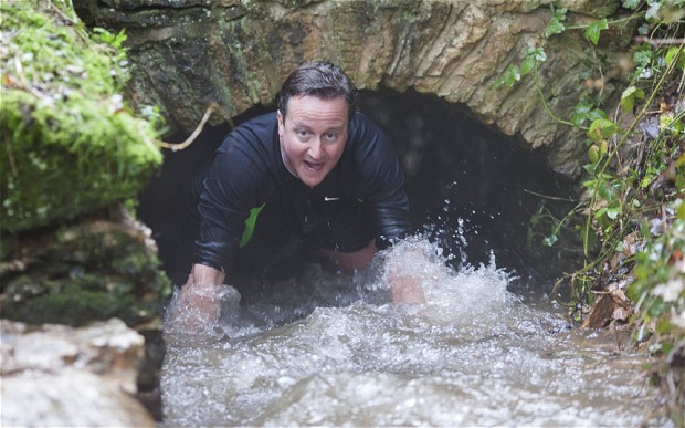 Check out the wild-eyed grin of a man finding himself in deeper water than expected… The Met Office reports that, since records began being collected just over a century ago, in 1910, six of the UK’s ten wettest years have occurred since 1998. That’s a pretty striking figure, which would appear to suggest that our climate is changing for the wetter… Scientists anticipate that the effects of climate change, here in the UK this coming century, will probably be primarily “hydrological”: that is, more than feeling markedly hotter or colder, we will find ourselves getting either a lot wetter, and/or suffering more from drought…
That said, the Met Office is careful to specify that Britain has always seen periods of wetter and dryer weather in the past, and that it’s difficult to attribute any one weather pattern confidently to the global issue of “anthropogenic climate change”. What we have had this year, apparently, is a “buckled jet stream” – which has meant that wet weather off the Atlantic that normally gets pushed much further north has been hitting the UK on a regular basis…
Thankfully, the Shipley area has not been directly affected by serious flooding this year in the way that some other parts of Yorkshire have been (notably in the Calder and Ouse catchments), but it’s worth noting that the River Aire has exhibited a broadly similar pattern of high water to other parts of the UK since 1998… Water levels on the Aire are gauged downstream at Armley, and this graph shows clearly how the last decade or so has seen especially high water levels…
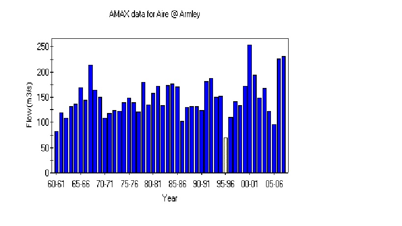 This graph is taken from the National River Flow Archive and you can clearly see how the year 2000 – the year a really big flood hit Shipley in October – almost broke the scale. Water flow on the Aire hit as high as 250 cubic metres per second (see horizontal graph side), in comparison with an average (median) flow of just under 140 m3/s. The years 2007-08, when further high water was experienced in the area, also figure prominently on the chart (exceeding the levels experienced in the – nationally very wet – year of 1968). This pattern broadly squares up with the country-wide figures. In the UK as a whole, 2000 and 2008 were the wettest years on record prior to this one – apart from 1954. If you take England separately, it’s 2000 and 2002 – separated only by 1960 and 1912.
The other thing that’s changing, though, is the predictably of when in the year rain will fall. Remember all that concern earlier this year about potential drought and water shortages? It seems laughable now, but the issue had been a lack of winter rain over several years – the season during which rain stays in the ground and is stored for future possible use. Summer rain, by comparison, tends simply to get evaporated or drain away quickly, so it’s less use to water companies — and of course it was summer rain that caused all the flooding problems in Hedben Bridge and elsewhere this year. The graph below (again from the Armley gauge figures) collects the monthly flow rates from 1961 to 2010, and shows the normal, expected pattern of more rain falling in the winter months…
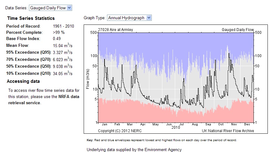 This year, by contrast, the river flow was so high in the summer, that the flood-gates on the Aire-Calder Navigation had to be closed during August – an unheard-of eventuality.
If you’re bored by all these statistics, a more entertaining picture of high water levels on the Aire emerges from the pre-1910 records collected in the British Hydrological Society’s British Chronology of Hydrological Events – where you can find a collection of narrative accounts from earlier centuries…. Obviously, this is patchy, unreliable story, because nobody was recording this stuff systematically back then. But some of the stories make for great reading. In what follows, I’ve highlighted some particularly soggy years in the Aire catchment… Many of these are accounts of events in Leeds (more people around to record them…), but of course high water in Leeds is a sure sign that there’s high water upstream in the Shipley area too…
1767 (August) The river level in Leeds, we are told, “rose six feet in a single hour.” (Wow!)
1775 (October) A deluge lasting 36 hours left the whole riverside area in Leeds under water: “large quantities of grain deposited in Warehouses were washed away . . . several dwelling houses and dye-houses suffered greatly, dyeing vats being torn out of their places; the pavements in the streets broken up; walls thrown down; cows, horses and sheep forced into the water and drowned.”
1799 The River Aire was again “much out of its boundaries”, although the real story that year (as this) was to the south in the Calder valley… “The River Calder was never known to have been so high in the memory of man; and about Wakefield, and all the places near that river, considerable damage has been sustained.”
So the closing decades of the 18th Century were quite eventful. Then it all seems to go very quiet until the later stages of the 19th…
1866 (November) Serious flooding affected the City of Bradford (Bradford Beck broke its banks) and the Aire Valley as a whole… Four miles downstream from Shipley, at Apperley Bridge, the force of water flow caused the river to overflow its banks to a width of half a mile (!), and the water pressure seriously weakened the viaduct that carried the Midland Railway’s line from Leeds to Lancaster. The damage, the records tell us,
“was discovered that night [November 16th] by a platelayer returning home, who was walking over the viaduct when suddenly he all but fell into a rent that had appeared in the masonry of one of the arches. He had to jump across, then hurried on to Apperley station, where the stationmaster arranged to stop down trains; then both men and a porter rushed back along the line to halt an up goods that was due. Even before they reached the viaduct they saw it approaching on the far side. They waved red lights, and the driver spotted them and shut off steam; the fireman applied the brakes, and both driver and fireman then prudently jumped off. Propelled by its heavy train the engine ran out on to the broken arch of the viaduct, which, as F. S. Williams puts it in The Midland Railway, went down like a pack of cards. It carried with it engine, tender, guard’s brake, and a trainload of meat intended for the London market.”
Sounds like there were a lot of temporary vegetarians in London after that, but miraculously nobody was killed. Meanwhile, another bridge structure over the Aire that was permanently damaged by flooding that year was Leeds Bridge (the ancient crossing point first mentioned in documentary records as far back as 1383): “After the great flood of 1866 the Town Council decided to replace it with the present single span iron structure, designed by T. Steele of Newport, which opened in July 1873.”
1884 (Summer) The problem that year wasn’t flooding but drought. Between February and September, there was so little rainfall that, we are told, “the five inches of rain in July scarcely stirred the tributaries of the river Aire, the land having become so dry.” Indeed, water levels on the Leeds-Liverpool Canal were so low in these conditions that boat traffic stopped altogether that summer at Otterburn-in-Craven (up in what is now the BD23 postcode area… close to where the canal peaks over the Pennines, and is fed by a reservoir system flowing downhill both west and east… but not that year!).
1886 (May) Once again, we’re told, “rivers and their tributaries which were flooded and overflowed their banks [included] the Aire, Calder, Derwent (Yorks).”
1892 (October) An observer in Horsforth named Oliver Hill noted “extraordinary rain, 6.96 inches falling in three days [13th-15th], causing floods in the Aire valley. At Kirkstall Station the water stood 15 inches above the rails.”
1900 (July) Rainfall exceeding one inch in 24 hours was measured over an area of 1000 square miles in Yorkshire and Derbyshire on July 12th, with falls of more than three inches occurred over about 60 square miles. Widespread flooding and chaos cost the lives of 21 people in Leeds, Dewsbury, Keighley, Ripponden, Wakefield and Otley. Bradford, however, did not lose a life to the storm, despite ‘almost continuous’ lightning and thunder which was ‘a constant roar’. The flood damage, however, was considerable. In its bowl of hills, with only the narrow channel of Bradford Beck to absorb the water pouring in from all sides, the city (established as a city only 3 years earlier) was ill-equipped to deal with the deluge. The city centre was overrun by a “dirty flood”, and although this drained away into the ground a few hours, almost every cellar in the area remained flooded: a foot of water stood for a long time before dispersing, so that businesses were left counting the cost. Meanwhile, on the Canal Road stretch of Bradford Beck, leading north to Shipley and the Aire, some of the Beck’s containing walls collapsed, and the sewage works at Frizinghall overflowed, sending foul effluent downstream to Shipley.
The epicentre of the July deluge, however, was over Rombald’s Moor – the moorland area separating the Aire Valley at Shipley and Baildon from the Wharfe Valley at Ilkley (it includes the areas popularly referred to as Baildon Moor and Ilkley Moor). An Ilkley rain-gauge recorded 5.40 inches of rainfall that day, and – more precisely – “Mr Worfolk at Brook Street, Ilkley, recorded 3.75 inches in one hour and a quarter, between 2 p.m. and 3.15 p.m — an intensity never before recorded in this country as having been maintained for so long a time.” The worst of the storm run-off from the moor also seems to have flowed north into Ilkley, coming down particularly via Spicey Gill (also known as Parish Gill Beck), which runs into the middle of the town before intersecting with the Wharfe. Records show that
the first bridge where the Keighley road crosses [Spicey Gill], was carried away, [with] some parts of the Keighley road being covered to a depth of four feet by boulders…the largest of them measuring 4 ft. by 3 ft. by 3 ft….The whole valley of Spicey Gill above this point , though barely a mile in length, was completely changed, some parts of the deep narrow ravine were hollowed out, …while other parts were blocked up with the accumuated rubbish, and the stream diverted….. At 4 pm the swollen beck, washing against the wall of Mr Brogden’s coach-building shop in Bolton Bridge Road, caused a sudden collapse of the building in which Mr Brogden, junior, having delayed his escape for a moment in order to warn the workmen out of their workshop, was killed by the falling roof…
Following this deluge, everything in Ilkley was left covered with a layer of black mud, of between 12 and 18 inches in depth! Meanwhile, the same cloudburst over Romald’s Moor also caused Morton Beck (which flows south into the Aire in the Bingley area) to burst its banks, “sending torrents of water on a destructive rampage down to the River Aire” and badly damaging homes in Morton village. Nor was it only water that caused damage during the storm. West of Shipley, in Wilsden, four cows were struck dead by lightning as they stood in a field. Further west still, at Oxenhope, farmer William Smith was – we are told – “struck speechless” by lightning as he sat in his house… though fortunately he lived to, er, tell the tale…
1903 (October) Further flooding seen on the River Aire.
1908 During another day of summer thunderstorms – albeit not quite as severe as the one in July 1900 – more than an inch of rain fell over 100+ square miles of Yorkshire. The most intense rainfall, over four inches of it, fell in another moorland cloudburst, this time in the vicinity of the Barden Reservoir. Located in what is now the Yorkshire Dales National Park, this is the source of the Barden Aqueduct (constructed in 1850), which runs south east all the way into Bradford to provide the city’s water supply – running via Bolton Abbey and indeed Saltaire (where it crosses the Aire at the corner of the Higher Coach Road housing estate). Up at the aqueduct’s source on Barden Fell, records tell us,
channels cut out in a few hours by this storm were in some cases excavated to a depth of 20 feet in the solid grit, and the breadth in some cases was 12 feet. The water level rose 10 feet in Barden Beck, and much damage was done to the waterworks at Barden reservoirs, though the main retaining dams were too solidly constructed to give way… In Far Long Gill, another lateral stream flowing down to the reservoir on its south side, where the branch pipe-line is carried by a bridge over the stream, the flood took away the bridge, but happily did not carry the pipes with it…. By far the worst damage, however, has been done at the head of Lower Barden Reservoir: the debris brought down by the flood rapidly filled up the residuum lodge, burst through the embankment, and so forced its way direct into the main reservoir, carrying with it an enormous mass of sand, estimated at something like sixteen thousand cubic yards in volume…..’
1909 (December) An observer at Shipley noted the “highest flood in the River Aire since October 9th, 1903.”
… And that’s as far as the “British Chronology” takes us, because it was in 1910 that rainfall began being officially recorded by the Met Office, and we stop having to rely on these more fragmentary (though often fascinating!) accounts of unexpected water events…Though we know, of course, that heavy flooding was experienced in the Aire catchment in 1947 also: in Shipley the floods that year were the worst in living memory, until those that occurred in 2000.
And in conclusion…? Well, looking at this chronology, we’re perhaps necessarily reminded of the circumspection shown this week by the Met Office. If the weather has been exceptionally wet this year and in other recent years, we can’t attribute this conclusively to “climate change” because history has seen other periods of more intensely screwy weather too… It would appear, in fact, that in the Yorkshire area the floods of 2000 and 2008 were foreshadowed exactly a century earlier, in 1900 and 1908, by particularly intense and destructive rainfall events. Indeed, the 3-decade period from the 1880s to 1910 seems to have seen more chaotic rainfall events than had occurred during the whole of the preceding century (although this might in part be because recording methods were becoming more reliable?), or indeed during most of the rest of the 20th century.
Are we in another such period of cyclical wetness now? Or is this current streak symptomatic of worse to come this century, as many scientists predict? It’s too early to say with any confidence, but we’d surely be as well to take more precautions than Mr. Cameron’s government is currently considering… Flood defence spending has been massively cut by the coalition (down from £354 million on new projects in 2010-11 to around £259 million in 2011-12). After a year in which the Environment Agency felt obliged to issue flood warnings to around 200,000 UK homes, the Chancellor’s autumn statement contained measures to reverse some of the cuts, but according to the government’s own advisory body on adapting to climate change, there is now a funding gap of almost £1 billion opening up between what is needed to keep properties protected and what is being spent in the next few years. Stand by to get wet.

