This time last year, I was trying to keep this blog updated with the crisis that was the Boxing Day flood of 2015. Thankfully, things have been a lot quieter this Christmas, so I’ve been able to devote a bit of ‘down time’ to some more historical water stories. Specifically, I’ve been puzzling over old maps, trying to figure out the history of how homes and industry developed in the Dockfield area of Shipley (and the Lower Holme area of Baildon, just across the river footbridge). It’s more fun than a jigsaw puzzle…
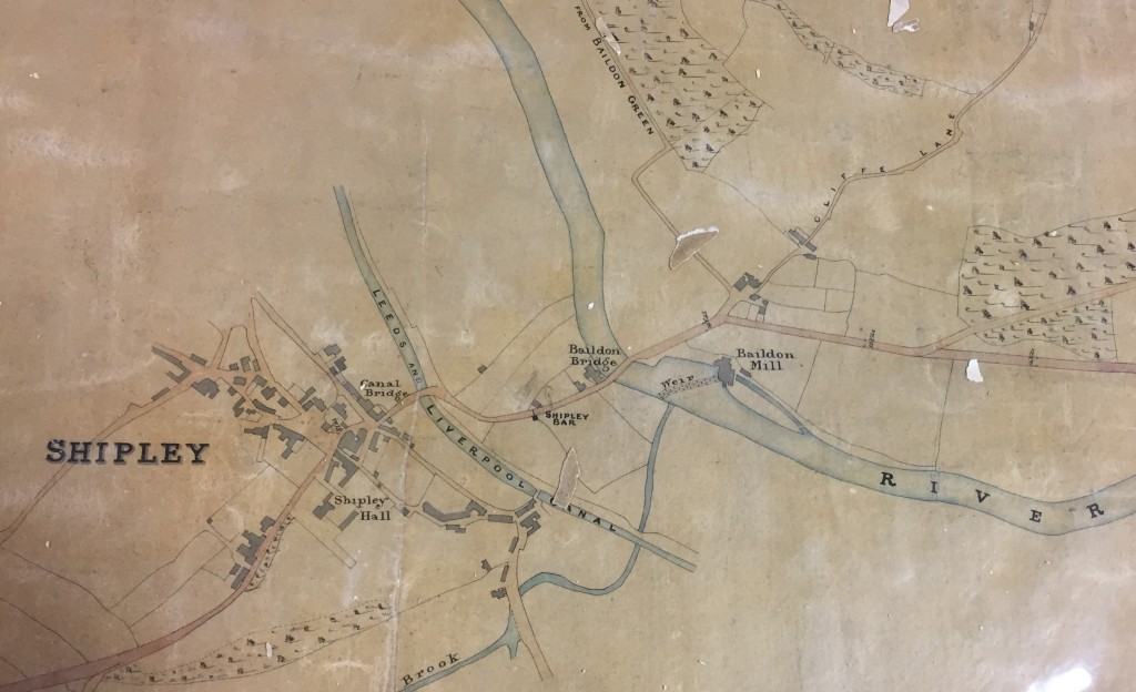
Dockfied is an area defined by water on all sides — the River Aire to the north, the Leeds-Liverpool Canal parallel to the south, and Bradford Beck to the west (flowing north to meet the Aire). But as you can see from this 1837 map, above, it was not even dreamed of at that point in time. Shipley was then a small town whose centre was slightly further west than it is now, clustered around the road leading off the original Canal Bridge (now Victoria Street Bridge), before the Otley Road bridge and Foxes Corner junction even existed. East of the Beck (or “Brook”, as this map has it), was simply farmers’ fields. By 1852, though — the date of this next map — there are sure signs of industrialisation…
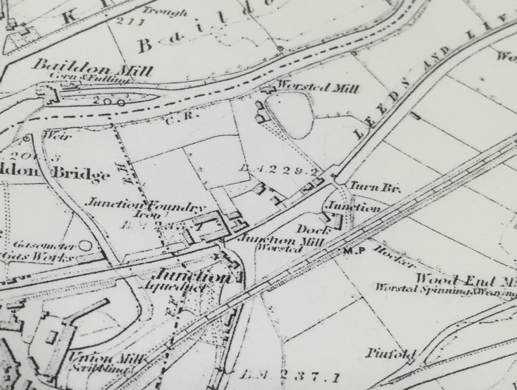 Not far to the west, Salts Mill was nearing completion and about to open — in 1853. But here, in addition to Baildon Mill (the old water mill on the Aire, also visible in our earlier map), we can now see Junction Mill — in the spot where it still stands, directly to the east of Bradford Beck, and facing Junction Bridge — the original canal bridge that allowed horses to cross from the towpath of the Leeds-Liverpool to the towpath of the Bradford Canal (hence “junction”). Also in what’s to become known as Dockfield, there on the southern bank of the Aire, is another, as-yet unnamed “Worsted Mill“.
Neither of these two new mills would have had water wheels (or their attendant weirs). This was now the age of steam engines. But still, you need water to make steam. Junction Mill appears to have been getting its supply from the river via the “Junction Aqueduct” (Salts Mill had a similar pipeline set-up), but the smaller worsted mill had clearly opted to site itself right next to the river. This meant that it didn’t face onto the canal, as Junction Mill did, so to get access to this vital transport and haulage route, a road of sorts has been constructed between the mill and a small “Dock” on the southern edge of the canal. And a swing bridge (or “Turn Bridge”) has been installed to provide access across the canal itself. Notice that, at this stage, Dock Lane does not appear to extend any further: it is literally just a lane linking the riverside mill to the canal dock.
Taken together, the appearance of these two mills gives a clear indication of what the appeal of this area was to industrialists: you needed both the river for a ready water supply and the canal for transportation, and in the Shipley area you had both, running in parallel. Of course, rail is another transport option, and already in this 1852 picture above you can already see the clear line of what was then the Midland Railway, running roughly parallel to the canal, just to the south. But stations were fewer and further between on a railway, so the canal still had a clear appeal for its readier freight access (just as road haulage is, today, much more convenient than rail for most businesses).
Now let’s spool forward another 40 years, to the first modern Ordnance Survey map, printed in 1893:
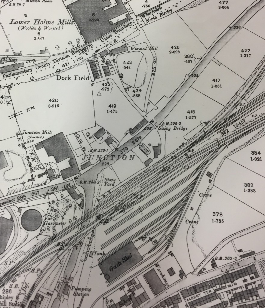 Notice, first, the appearance of the words Dock Field on this map. The area has found its name — a name that presumably refers simply to the fact that there is a dock right there in the middle of a field… But the words actually appear next to the first row of houses in the area, which have no doubt been built to house the worsted mill’s growing workforce. These houses, now known as Dockfield Place, are still in use today.
Notice, though, how the riverside worsted mill has now been dwarfed by the erection of the Lower Holme mill, directly across the river. This Baildon site, bought up by Titus Salt in 1850 (apparently before he decided where to site Saltaire), was sold on to C.F. Taylor in 1862, and it was Taylor who then built the large mill building next to the river (again, water supply…). He must also have been responsible for building the bridge across the river, in order to connect to Dock Lane and, thus, the canal dock. Although the present, 1960s bridge structure is just a footbridge, it must originally have been wide enough for wagons — which also explains why the road running down to it has always been full road-width (at least until the arrival of the controversial “landscaping” — aka a long row of dumped earth — that was left along the edge of the Wickes overspill car park when the site was redeveloped in 2014… still a sore point with residents!).
I can’t easily show you the Lower Holme cottages north of the mill, because in a quirk of OS mapping, there’s a key grid line that runs through here that always carves the mill and cottages onto two separate pages of the maps. So we’ll come back to the Baildon side of things at the end of this post… Sticking for now with Dock Lane, notice how — in the 1893 map above — the lane now continues alongside the railway and then underneath it by the canal junction. It then runs alongside the Bradford Canal (long since filled in, of course) to connect with the Leeds Road, just as it still does today. Finally in the 1893 map above, note also the massive expansion of railway sidings to the south of the mainline.
The next map is from 1908, just fifteen years later…
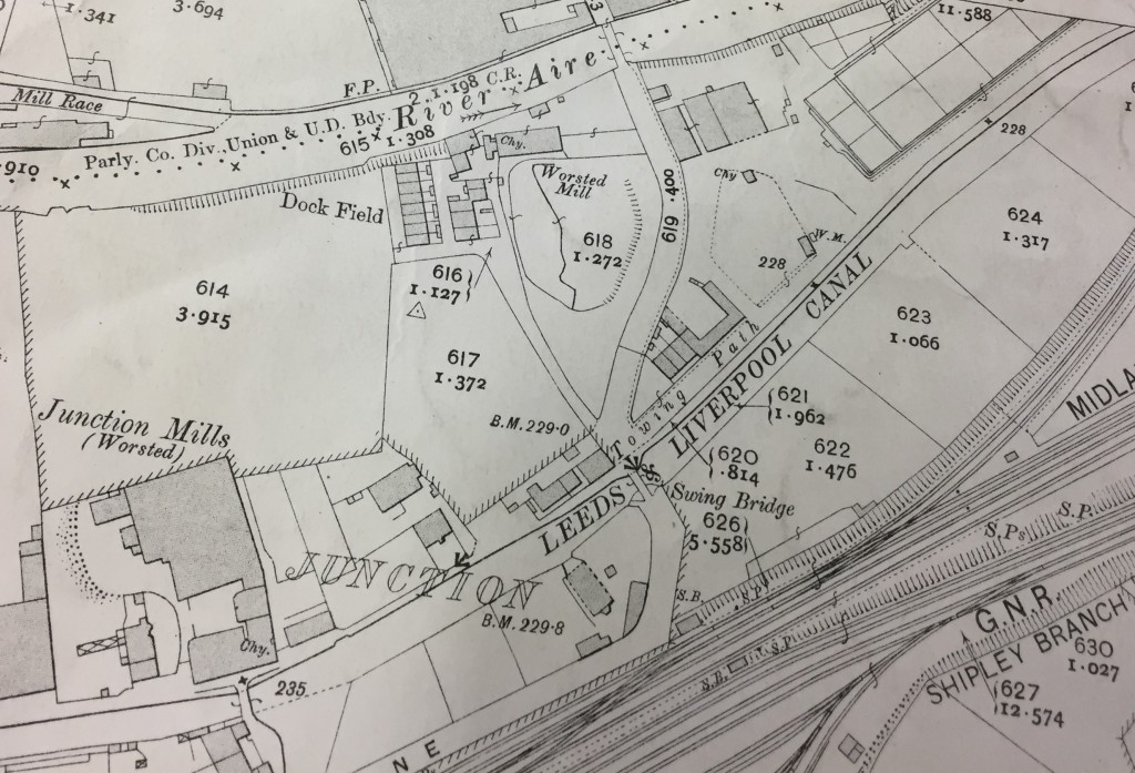 At first glance you might think this looks much the same as in 1893. But notice the developments to the east of Dock Lane, between river and canal. A small row of houses has now appeared along the towpath to the east of the swing bridge — houses which still stand today on Dockfield Road (though the road did not yet exist when they were built). These houses and the other new buildings to the north have apparently been built to service the new Sewage Works that Shipley Urban District Council has recently been building. The long, rectangular in the top right of the image above will soon be more clearly delineated as sewage settling tanks. So… the outlines of the Dockfields “island” (as some residents call it) are now clearly defined: river, beck, and canal to the north, west and south, and wastewater treatment to the east…
The sewage works’ arrival was the result of developments in local government and sanitation around the end of the 19th Century. The SUDC was created from the old Shipley Local Board, and one of its main reasons for being was to bring proper drainage and sewerage to Shipley — by eliminating the old middens and cesspits, and providing new homes with proper plumbing. A new sewage main running west to east along the Aire valley through the whole of Shipley parish now emptied into these wastewater treatment works at what was then the easternmost edge of the town. Indeed, technically (as 19th C. maps make clear), the area east of Bradford Beck was in the parish of Idle, not Shipley, so in effect Shipley was dumping its waste on the threshold of its neighbour.
But Shipley Urban District Council was not done yet… Look at this next OS map, from 1922 (? ish).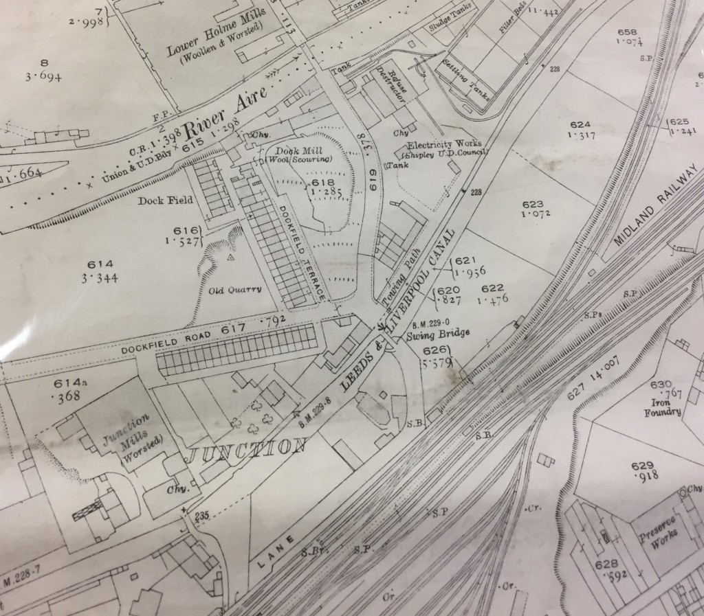
The new sewage works are more clearly labelled now. The worsted mill on the riverbank has now finally acquired the name of Dock Mill. But most strikingly, we now have the spanking new Dockfield Road, leading all the way up from Otley Road, at Baildon Bridge. The road has been built by the SUDC to provide better access to the sewage works and thus take the pressure off Dock Lane (which was no longer fit for purpose, with the mounting volume of traffic, and with that low bridge under the railway). Along Dockfield Road and the adjoining Dockfield Terrace (which links to the older homes nearer the mill) we now have two rows of early council housing — homes literally built by Shipley Council, with the very latest spec in plumbing and drainage… This was an early statement about the unsuitability of the old back-to-back homes in the Windhill area — visible in the bottom of the 1893 map above, and eventually demolished by SUDC in the years after World War II.
If we fast forward again to 1934, the full scale of Dockfield’s industrial development has now become apparent…
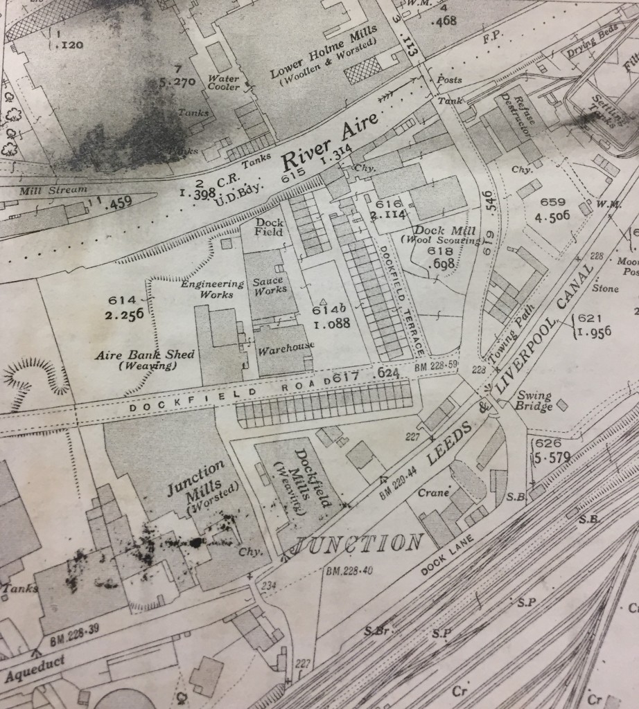 West of Dockfield Terrace, the Hammond Sauce works has now set up shop, and there’s also a weaving shed and small engineering works alongside the sauce. Dockfield Mills has now been built on the canal bank next to Junction Mills (also still standing today). Dock Mill itself has further expanded, and there are more buildings around the canal dock (presumably warehousing, to cope with the increased capacity now needed). This is Dockfield at its industrial height.
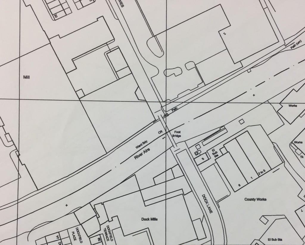
Now then… All of these map images are close-up photographs I’ve taken from the large maps on display to the public in Bradford Central Library’s Local Studies section. (There’s no indication there of any copyright issues with the maps, so hopefully I’m not breaking any laws here.) But for some reason the library’s big maps don’t go past 1934. After that we move to a different scale of OS mapping, but we also make a huge leap to 2003…
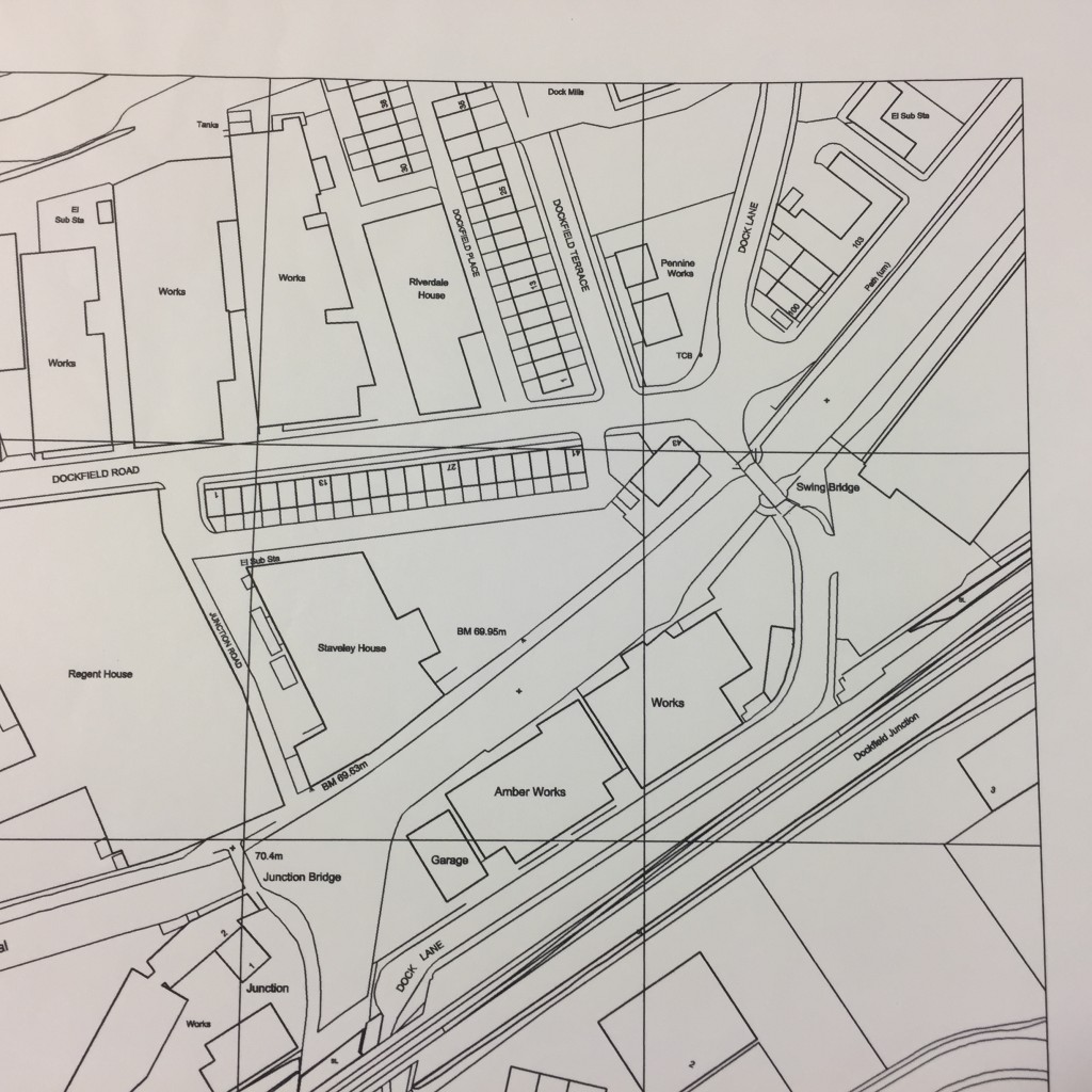 What’s perhaps most noticeable here, apart from the altered graphics, is just how little has changed since the 1930s. In the map above, Dock Mills is still there, and the various “Works” to the west of Dockfield Terrace. But Junction Mills has been renamed “Regent House” and Dockfield Mills is “Staveley House”. These name changes are indicative of a change in use from industrial space to office space, in this “post-industrial period” after Mrs. Thatcher murdered the country’s manufacturing base in the 1980s…
Notice, too, that at some point since the 1930s, the old canal dock has been filled in (the canal’s “super slow way” no longer being a viable freight transport option in this high speed era). More “works” have been built over the docks area, although — in 2003 — these are just about to be demolished. One of these buildings, Amber Works, will very shortly give its name to Amber Wharf, the new-build apartment complex built along the southern bank of the canal. (The first flats at Amber Wharf were sold in 2007 — right before the bottom fell out of the property market…) Dock Mills, too, will shortly disappear, to be replaced by the new-build riverside flats whose street address is still Dock Mill.
Notice that, at some point between 1934 and 2003, the OS maps also seem to have moved their grid slightly, so that the page cut-off now happens south of the river, rather than north of it… Below is the connecting page, from 2003, with Dockfield now linking clearly across to Lower Holme, via the modern footbridge structure…
The Lower Holme mill has yet to be demolished (that would take another 5 or 6 years). And notice, on this map, that there are still “County Works” east of Dock Lane on the Shipley side of the river. Shipley’s sewage works were long gone by 2003, the wastewater treatment having been moved down to Esholt back in the 1950s (the land to the east that had once been an array of settling tanks and filter beds was redeveloped for more manufacturing, such as the Metal Box engineering plant that’s still there today). That said, there’s still a sewage pumping station next to the river, pushing the stuff on towards Esholt, and there are still electricity substations on this site, as on the map above. What’s changed now, of course, is that the County Works site has been sold off to the local success story that is Saltaire Brewery. Personally I’m a big fan of the Saltaire Blonde and their other beers, but next time you have a pint of theirs, it’s worth reflecting on the fact that it was brewed in a building that was once (according to the maps above) the “Refuse Destructor” for Shipley’s wastewater.
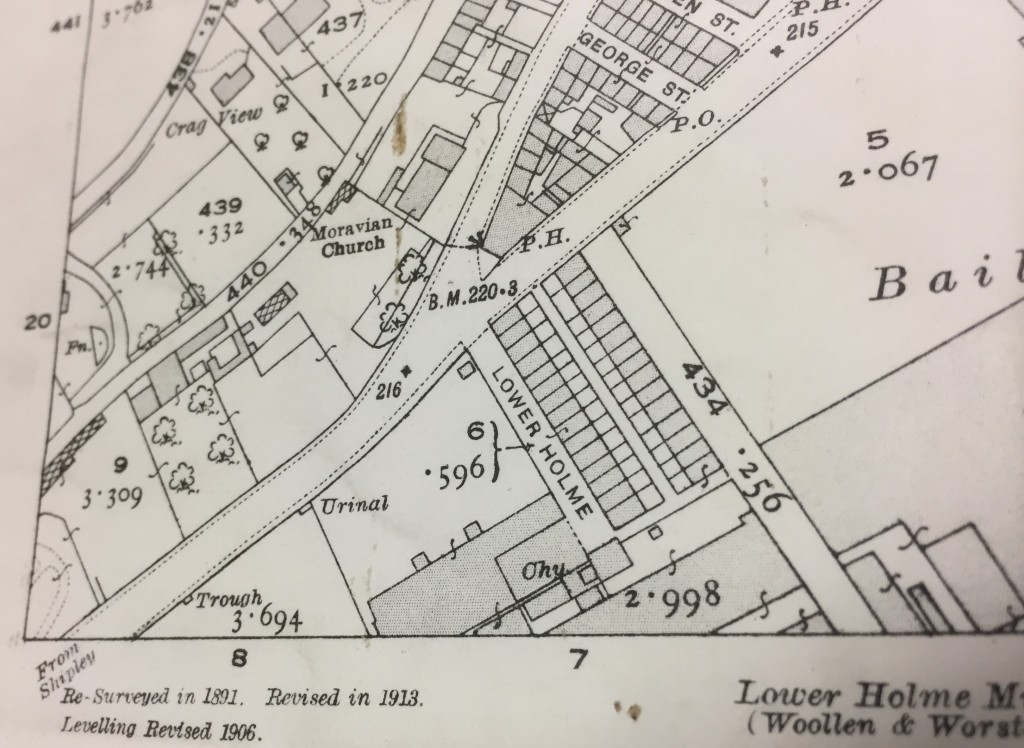
On that note, let’s cross the river again and jump back to the earlier maps for Lower Holme, across that OS boundary line… Here’s the 1893 OS map for the area immediately north of the river, around the junction of Otley Road and Baildon Road:
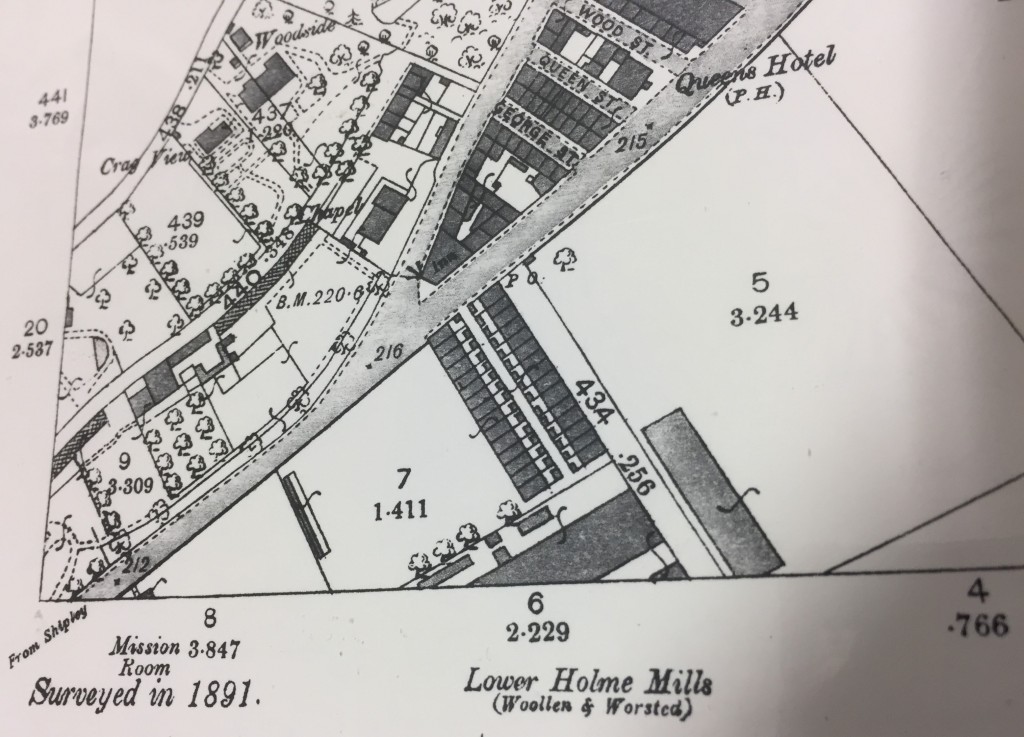 The “inn” at the junction (aka the Junction pub) stands on the corner just as it does today. And south of Otley Road you can already see the distinctive twin lines of the Lower Holme mill cottages, also still standing. However, the area immediately west of these homes (where KFC is today!) appears to be green space at this point (note the little tree drawings!). The houses are separate from the mill itself, even though they’ve been built to house C.F. Taylor’s workforce. The mill is set back from the road because, as was noted earlier, it’s the water supply from the river that Taylor needs most. That and the canal access, across the river bridge.
Jump forward to the 1913 revision (above), and the Lower Holme mill works are starting to encroach on the land west of the houses. There’s also been more development on the site to the east (also originally part of Taylor’s operation). And along the main road, notice the apperance of “Urinal” and “Trough” — all part of the public sanitation drive being pursued by Baildon Urban District Council at this time, in parallel with Shipley’s.
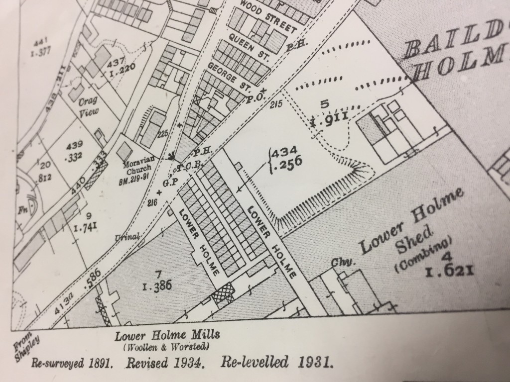 By the time of the 1934 revision, above, the houses are pretty much surrounded… Industry at its height! The mill buildings, of course, have all now been demolished — within the living memory of some of those still living on Lower Holme.
So all in all, this area is a story of industrial rise and fall… industries dependent on water supplies, water transport, and (arguably most important to the area’s modern development) water treatment. But if the manufacturing has largely gone, or transmuted into service-sector industries like brewing and (down Dockfield Road at Funopolis) recreation, it’s important to remember that the homes built to house the area’s workers are all still standing. None of these have been demolished, because they’re good homes… the solidly domestic legacy of a bygone industrial era.

I am a resident on Lower Holme. Do you have any recent photos of the cobbled road between the two rows of terrace houses which show the cobbles.
Northern gas have been on the street this week and dug up the cobbles and replaced a section of the street with concrete. When I have asked them to return the cobbles they claim part of the middle road was always concrete but I only remember a full street of cobbles. I wondered if you have an image of the street to confirm or deny Northern Gas claim.
See my Facebook pages ‘The Idle Line’ which features the former GN railway from Ship!ey & Windhill station.