
 This is me, taking a selfie, rocking head-to-toe orange. Something of a contrast to my usual look, but this is a blog post about contrasts. I’ll explain the new look shortly, but first…
The last couple of weeks have seen striking contrasts in weather patterns (climate change? wot climate change?). At the peak of a mini-heatwave that had us all sweating, June 21st was the hottest June day in the UK in 40 years. But only a week later, after several days of persistent rain, Bradford was once again facing flood warnings across the district — with water at perilously high levels in the Shipley area along both Bradford Beck and the main River Aire. Appropriate, then, that we also saw the publication this week of a long-awaited council report on Bradford’s preparedness for future flooding — which concludes that the serious budgetary cutbacks Bradford has experienced in recent years has left it vulnerable and exposed to “accelerating climate change risks”.
This report, from a committee chaired by Shipley’s own Green party councillor (and all-round lovely human) Kevin Warnes, is far better-informed than another report published last autumn by a different committee (which I critiqued in this previous blog post), and took advice from local figures who really do know what they’re talking about (such as the chairmen, respectively, of the Aire Rivers Trust and the Friends’ of Bradford’s Becks, Geoff Roberts and Barney Lerner). And while the report is frank about some of the council’s own failings, its key conclusion about insufficient funding points the finger (implicitly) right back at central government — since Bradford is among those councils who have been most disproportionately hit by austerity-era cutbacks (and faces another £32 million in cuts over the next couple of years). My last post on this blog was – in part – about the desperate under-funding of social housing in the area, but the shortage of adequate flood defences is symptomatic of related economic disparities…
Speaking of which… if we’re looking for contrasts, let’s head 12 miles downstream to Leeds, where a very expensive bit of flood engineering is still under construction…
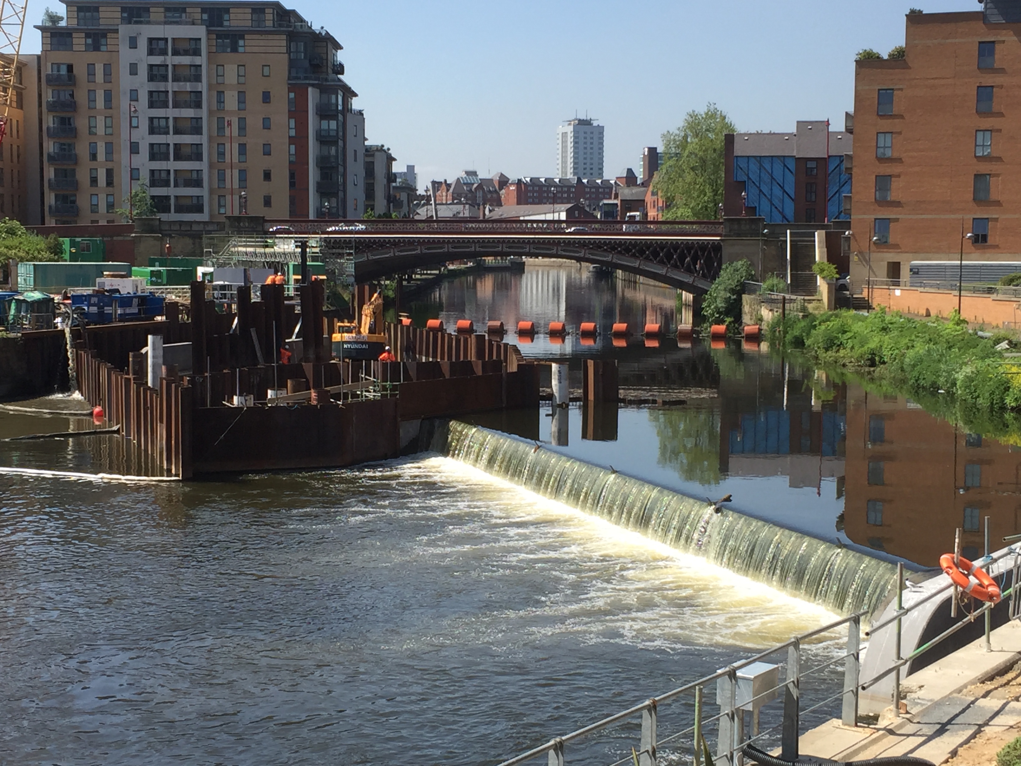
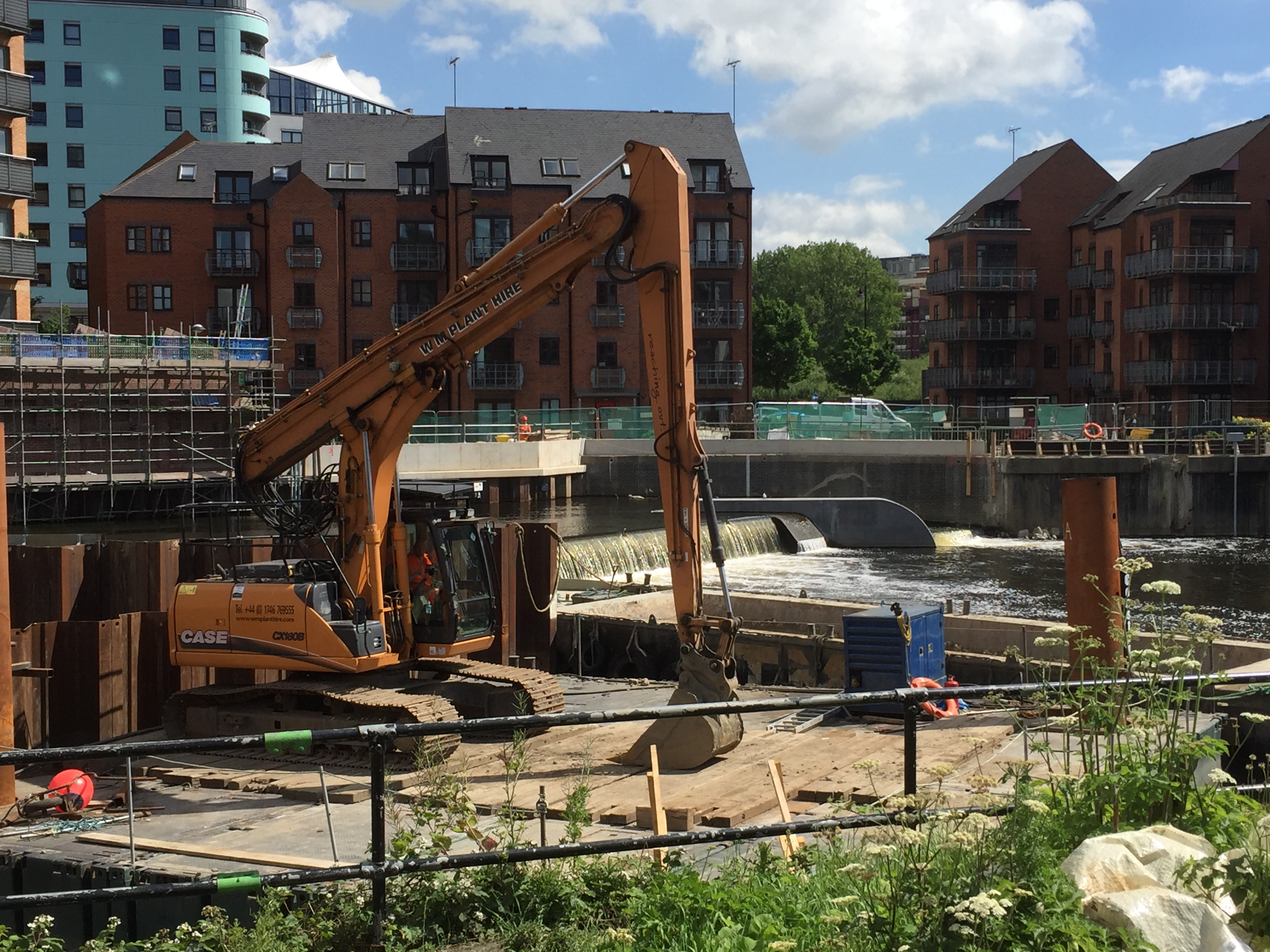
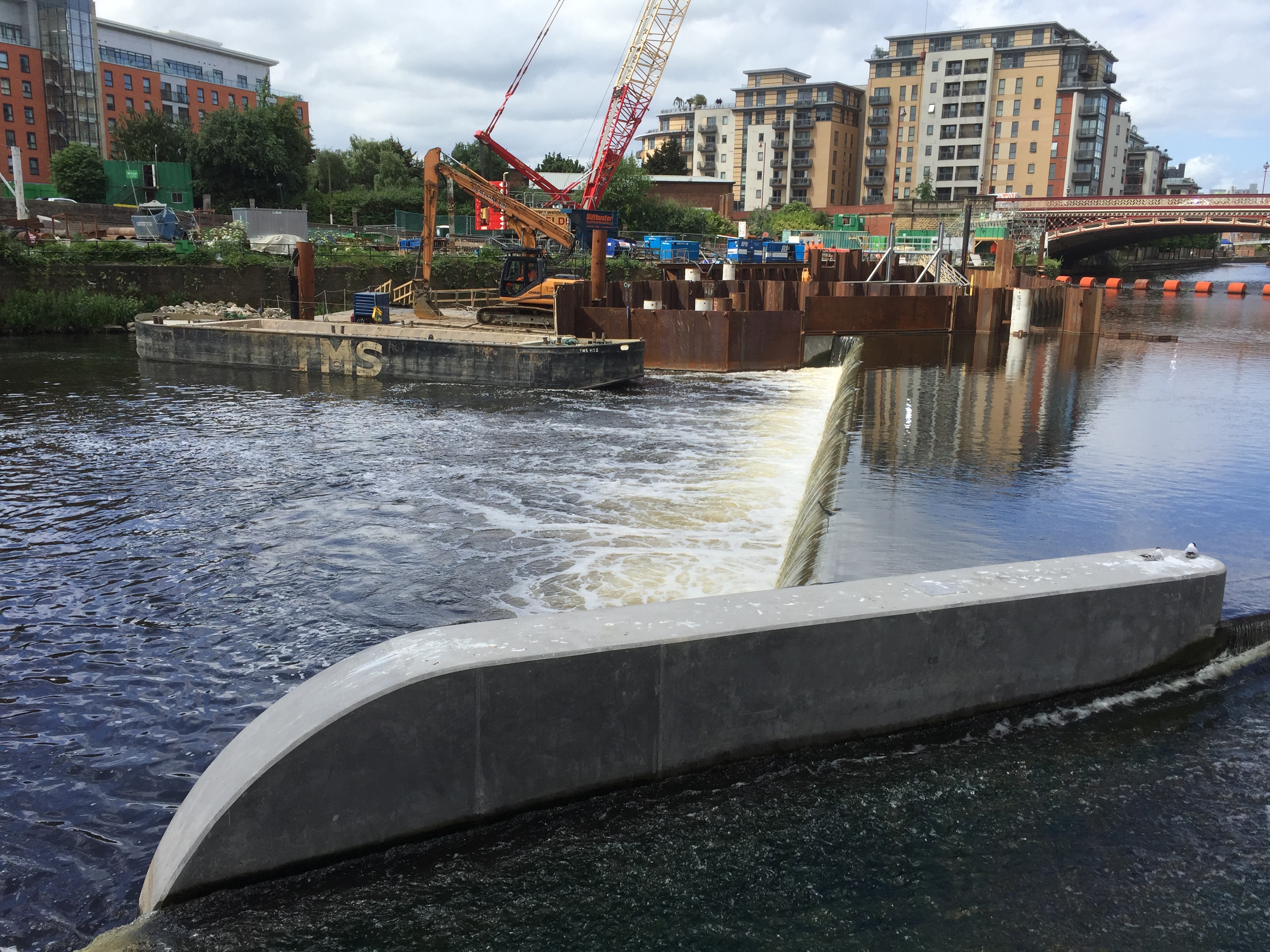
This is the weir at Crown Point — aka Leeds Dam. The rather aesthetically appealing waterfall effect on the right of the picture (i.e. the north side of the river) is created by the brand-new, state-of-the-art weir installation that has replaced the old industrial weir (versions of which have held up water here for about 700 years). The idea with this new weir is that it gets lower – or even disappears completely – in high water conditions, thanks to the pressurised air bladders underneath it, which can simply be deflated to lower the level of the water on the upstream side. It’s the first time this technology has been used in the UK as a flood alleviation measure – and it’s being installed not just here at Crown Point but downstream (on an even larger scale) at Knostrop weir. These weirs, combined with the new flood walls running through the city centre, up as far as the railway station, comprise Phase 1 of the Leeds Flood Alleviation Scheme (FAS).
This £47million scheme (underwritten by the City Council, with central government support) will soon be followed by the even more expensive Phase 2 – covering points east through Kirkstall to Horsforth – using money provided by then-Chancellor George Osborne in the aftermath of the Boxing Day floods of 2015. Bradford, by contrast, was offered nothing — and the big difference of course is that money follows money. Or, to mis-paraphrase the biblical parable of the talents: “To those that have shall be given more.”
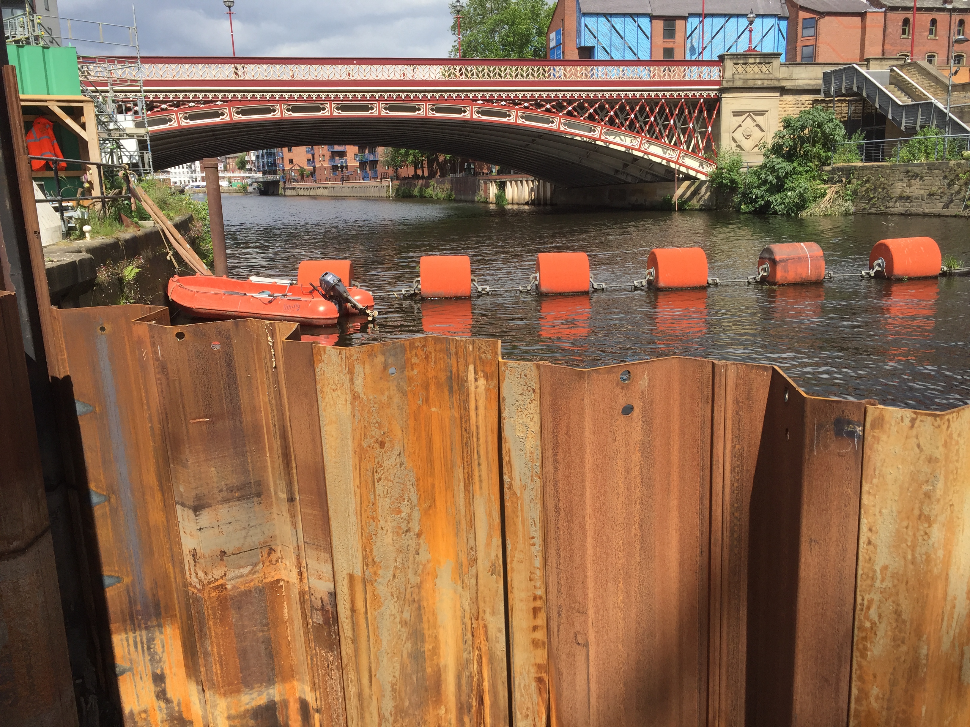
It’s apparently quite unusual, in the world of flood defences, for so many millions to be spent on such a specific, geographically-limited scheme as this. It’s reckoned that the new Crown Point weir, when lowered, will reduce upstream river levels on the Aire about as far as Victoria Bridge — so not even quite as far as the station. That’s a fairly short stretch of river, but it’s an extremely high value stretch of river. Better flood protection here will mean greater peace of mind for the major businesses and residential complexes on either side of the river — and will make it more likely that further inward investment will flow in to the city (especially in terms of the mooted regeneration of the South Bank area). So that’s why this investment has been made… and the results are, let’s be honest, pretty awe-inspiring… That coffer dam is quite literally holding back the River Aire, so that contractors have access to the riverbed.
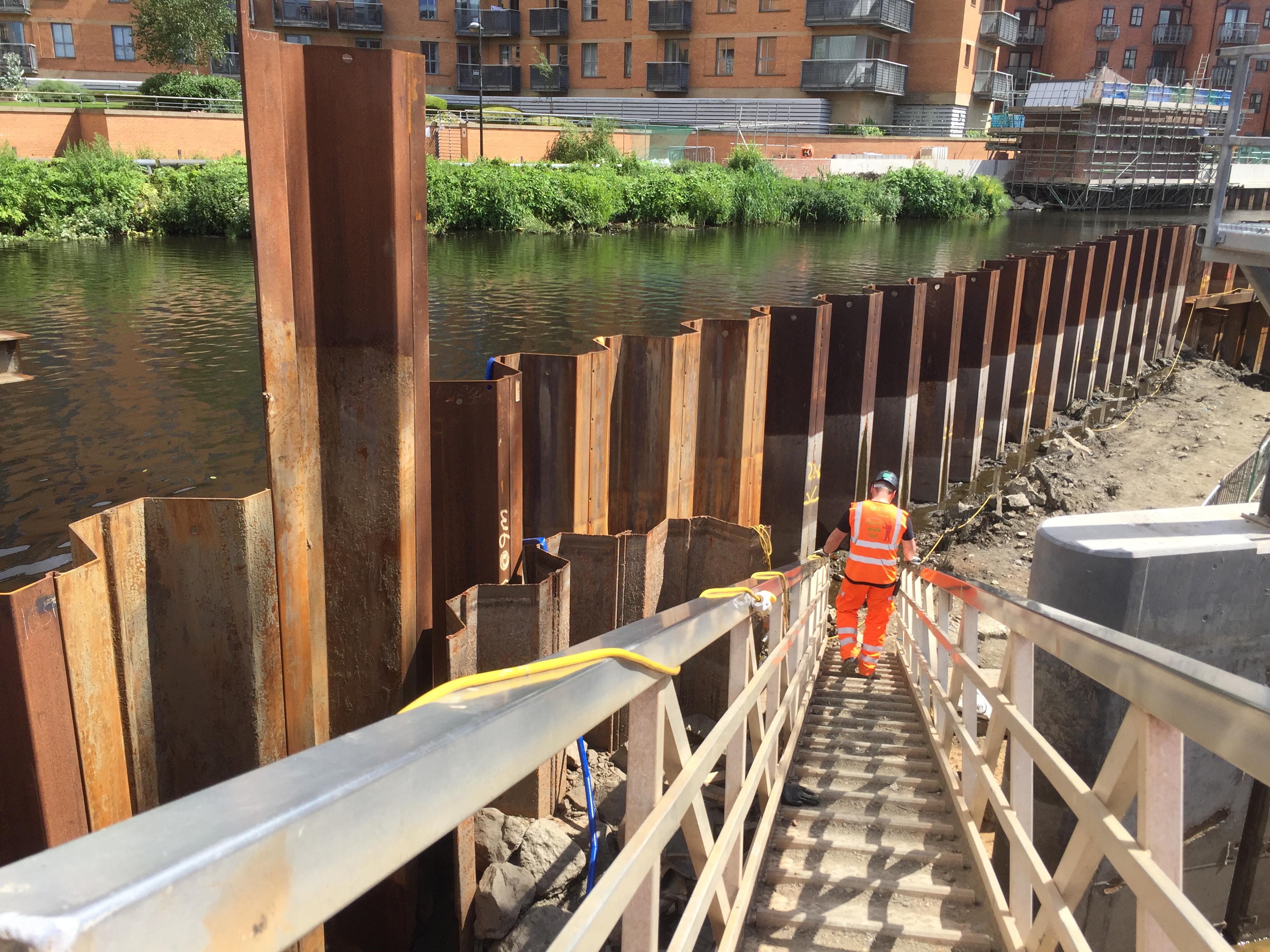
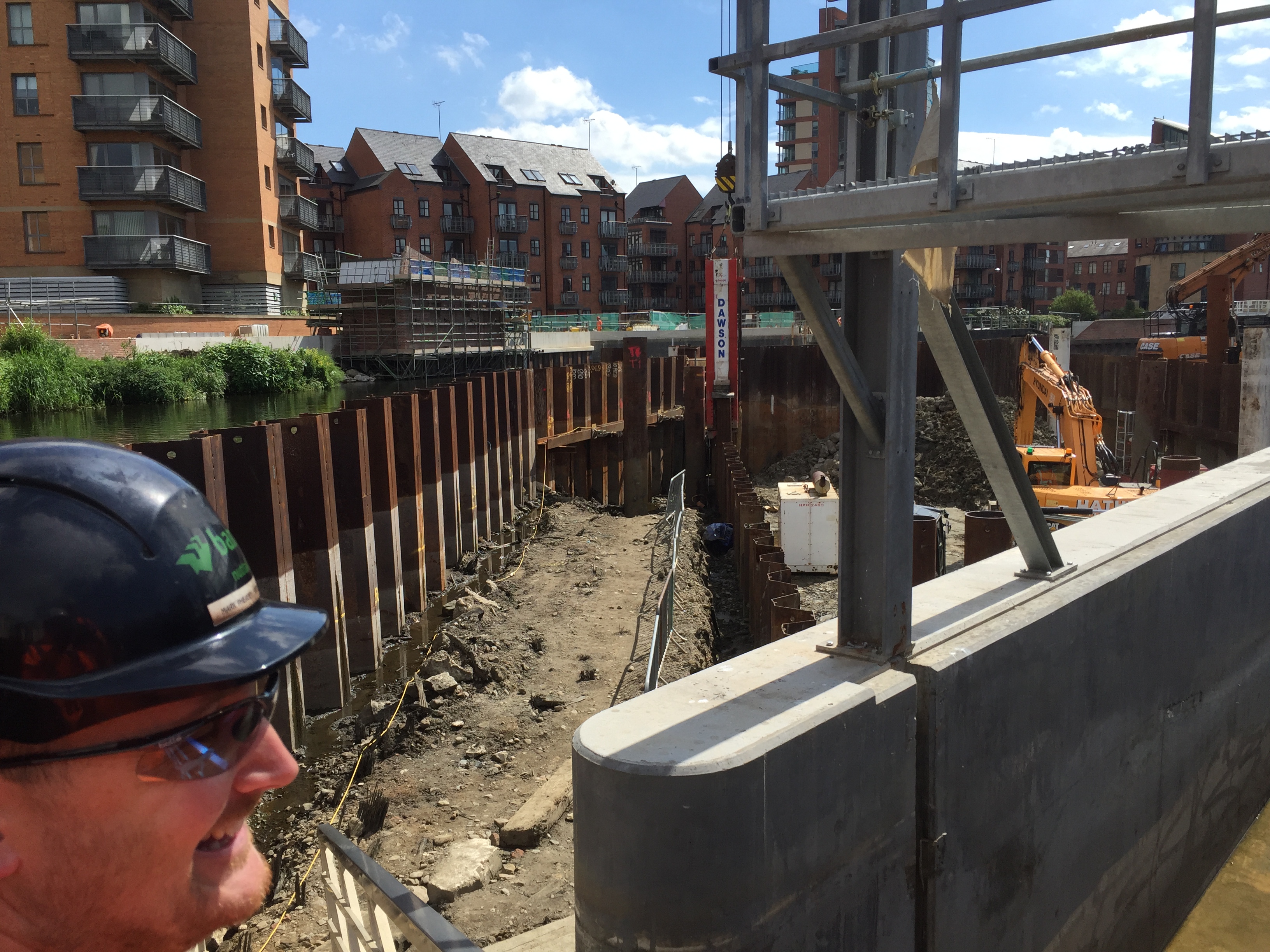
This is FAS foreman Mark Pheasey, descending the gangway into the coffer dam, where the second section of the new collapsible weir is currently under construction (it’s now due for completion around September). Mark, also pictured below, is one of my new favourite people — helpful, generous, knowledgeable — after being assigned by his employers, the engineering contractors BAM Nuttall, to show me around the site…
I was granted this privileged access (and required to wear orange) as part of my preparation and research for Weir Science — our latest Multi-Story Water performance project, which I’ll document in the promised “Part Two” of this blog post. For now, though, just check out the big boys’ toys…

This is the main crane on site, weighing in at a modest 250 tonnes. The counter-weight alone (the big red bit on the back) is 86 tonnes. Mark laughed when I expressed amazement at this behemoth, because BAM deals with much bigger cranes on other sites. But still, it is way too big to have been driven here… It had to be assembled, here on Fearns Island (in the middle of the river), through the use of a smaller, mobile crane (a mere 110 tonnes) that was driven across to the island via a temporary stone bridge – erected across the narrowest part of the navigation. The big crane is basically being used as a very large coat-hanger from which to suspend equipment like this… (press play and insert fingers in ears…)
This hammer is pile-driving sheet metal… It’s the stuff the coffer dam is made of, but the row going in here is part of the permanent foundations for the new weir. This is “heavy metal” in action, and it’s being installed by a team of highly skilled contractors. BAM workers get assigned to work around the country in teams, where they’re most needed (Mark’s home is in Hartlepool – so mostly he only gets back to see his family at weekends). The guy you see in the video above, lining up the hammer so it falls just right, has been doing work like this for decades. (I didn’t catch his name, sorry…)
But if you’re not easily impressed by scale and power, you might prefer this bit of video instead…
Here we see the River Aire having a minor disagreement with the coffer dam holding it back, and leaking through the cracks to make a new, miniature river along its own river-bottom… A pump system is in operation to deal with this, 24/7.
Further along Fearns Island, we can glimpse the new weir doing its thing, while – across on the far side of the river – the new flood walls are still under construction (that white concrete will eventually have red-brick facing on it to blend in with the surrounding buildings). And to the left, also across on the far side, that scaffolding-covered block is the operations booth for the new system. Though the building itself isn’t finished yet, the key machinery has already been installed inside, as Mark showed me…
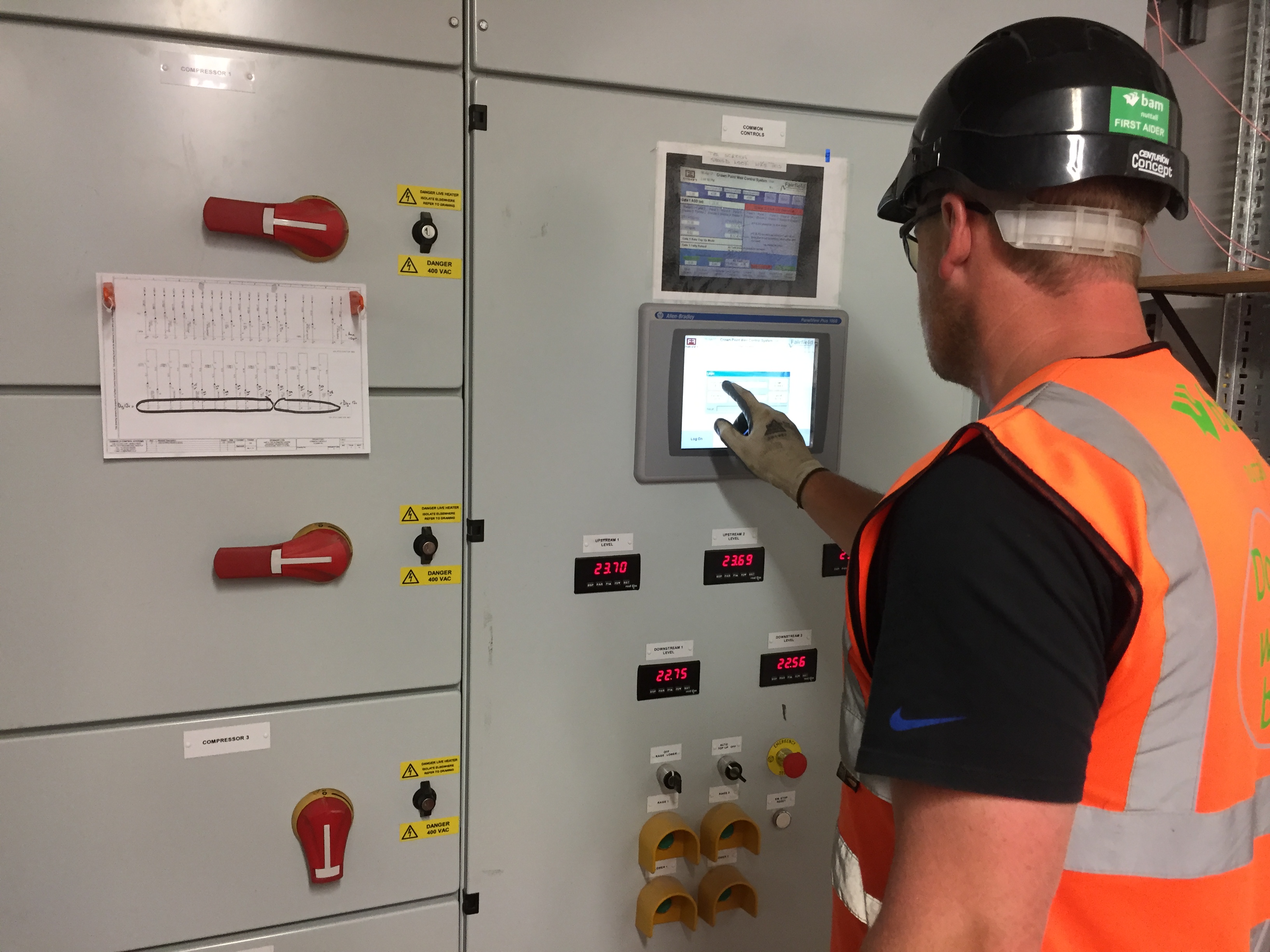
That touch-screen computer has adjacent settings on it for the two weir plates that will form part of the new weir. Since one of those plates is already operational, all the relevant readings are visible. But since the second plate is not yet installed (inside the coffer dam), that simply shows as being offline.
Whatever. I must admit that I was more drawn to the old school, lower-tech look of the pipes and dials below. And, yes, sadly, my inner child found some measure of amusement in the notice on the left…

Many thanks to Mark and BAM for a fascinating tour of the weir works. It gave me much of the material I needed for Weir Science, which we presented as part of the Leeds Waterfront Festival last weekend (June 24th/25th)… [see Part 2 of this blog].
Though based primarily in Shipley, the Multi-Story Water project has made annual forays downstream along the Aire to present performances at the LWF (see After the Flood and Seven Bridges under the Performance tab on the menu bar above). Working in Leeds has always felt like a different, but related context to Shipley, but this year the contrasts have seemed especially pronounced. Last year, an investigation led by this project established that there would be little to be gained, in terms of flood mitigation, by removing Shipley’s old industrial weirs. (Even if the money was available, which it isn’t.) In Leeds, though, they’re transforming a centuries-old landmark into contemporary art…
Excellent piece and a real contribution to the very necessary information/education campaign around this spectacular project, thanks Steve.
You raise the interesting , maybe I ought to say challenging, topic of funding schemes such as this – a topic that is on my mind as well. It seems to me that, in principle, those who are going to benefit from flood protection should be the ones to pay for it and a simplistic view of this would be that householders and businesses on the flood plain should be the primary payers – if you are daft enough to live on a flood plain then it’s your responsibility. Unfortunately this is FAR TOO simplistic.
Let’s start with the many social housing tenants living in properties on the flood plain – I can’t see their representations to social landlords being well received when they refuse accommodation because it might flood. And what about people who bought properties that were not believed likely to flood before the impact of climate change was modelled and now find themselves liable to flooding? Then we have to acknowledge that if protecting the flood plain brings business to the area then that business has benefits in terms of employment opportunities or economic benefits that stretch beyond the immediate area. What about infrastructure providers whose kit lies in floodplains and where the impact of losing that kit impacts a much wider population than those whose feet get wet?
So who should pay? Well at present the vast majority comes from ‘taxation’ via local or central government and maybe, for the reasons outlined above, it’s right that funding flood protection is a societal concern rather than just the responsibility of those occupying the floodplain. For me, the key question is about balance. If I have been sensible enough to buy a house on higher ground, or a flat on the 10th storey of one of those nice high rise developments around Leeds Dock, rather than one on the ground floor, should I contribute the same amount as someone who knowingly occupies a property on a flood plain? If I want to build my business by developing on a brownfield site near the river rather than invading the green belt should I be penalised for building on a floodplain or rewarded for developing previously derelict inner city land?
I wish I knew even some of the answers to what is a complex equation, perhaps this piece has illustrated for you just how it’s not as simple as some suggest.